CSV FDR File was altered to make aircraft appear on southern approach

Farmer initially entertained the notion that the data was tampered with, rather than a more mundane explanation like wind or IRS drift or whatever else he's recently discovered. It's been many moons since his initial claim and he's changed his mind in light of hard evidence; clearly not the actions of an idiot. Apologies to Mr. Farmer/911files.

on edit: I've seen some trolling in my time in this subforum, but sheesh. Enjoy the rest of your very short stay here, jryan1776. I normally welcome new folks here, but the only welcome I have for you is to my ignore list.
 
Last edited:
I keep on wondering how stupid these people can be when over 100 people saw the aircraft hit the Pentagon? Just another throttle-wanker who didn't make the cut.
 
I see Beachnut edited more into his post again. Like clockwork.

Just wanted to get the above quoted as i finally agree wih Beachnut. And if im still here by the time i can have a signature (i'll probably be banned soon like all of your "opposition"), it will be in my signature...

Thanks Beachnut!

Present the data and we can see if we were wrong about why the Balsamo sock was trying to sell it as support for dirt dumb ideas he has on 9/11. Simple stuff, bring in the work and show why it could support any of the dirt dumb ideas Balsamo’s sock had.

You do understand the work 9/11 files just presented here at JREF, and actually months ago ( I used it several times to show Balsamo’s ideas are false) he presented parts of his work he is still working on, refute Balsamo’s non-paths, and no theory ideas on 9/11.


It is ironic to see another Balsamo clone here at JREF. Is it a shot, or just the water?


Oops

Irony

erased tons of good stuff
Good stuff gone for ever. Wait, Balsamo always saves my posts, get the lost stuff from Balsamo, he said he keeps it. Now you will honor me with a sarcastic2 sig, nice.
 
Last edited:
Unless Farmer changed his "mind" in the past few days, he still maintains his calculations (not opinion) were correct and that the csv file has been "altered". His calculations claimed as "pseudoscience" by Anti-Sophist.

wow, i think that you haven't been reading what has been posted here.

Farmer's calculations are dealt over two threads here. care to try and read them all before making blanket statments


Oh, and please provide the math. we've been waiting for the mouthpieces for CIT and pft to provide them. since you're obviously shilling for them, you can also tell them to put up or shut up,


ETA; Also notice that you DELETED most of my reply you know where FARMER is doing something to understand things he didn't understand before.

Unlike your lazy friends who rather based their fair tale in misinterpreted quotes of 13 eye witnesses.
 
Last edited:
rather than a more mundane explanation like wind or IRS drift

So let me get this straight. IRS or Wind drift is present in the csv file and heading indicator in the animation provided and plotted by the NTSB (yes, Farmer also maintains the animation heading indicator was altered), but not in the file decoded by P4T (which lines up "perfectly" for the lamp posts, yet too high) for the same aircraft? You sure you work with avionics? Its clear you arent a pilot.

or whatever...

"or whatever"?

Yeah. as long as his "pseudoscience" supports the govt story, it doesnt matter anymore. We get it.

Farmer maintains his calculations are correct based on his analysis of the csv file provided and plotted by the NTSB. Its not based on "wind drift" or IRS" drift. Read his quotes on LCF that YOU quoted.

You do realize this thread is open to the public, right?

Although, it'll probably be moved to a section which is not. This is why its saved. :)
 
So let me get this straight. IRS or Wind drift is present in the csv file and heading indicator in the animation provided and plotted by the NTSB (yes, Farmer also maintains the animation heading indicator was altered), but not in the file decoded by P4T (which lines up "perfectly" for the lamp posts, yet too high) for the same aircraft? You sure you work with avionics? Its clear you arent a pilot.


"or whatever"?

Yeah. as long as his "pseudoscience" supports the govt story, it doesnt matter anymore. We get it.

Farmer maintains his calculations are correct based on his analysis of the csv file provided and plotted by the NTSB. Its not based on "wind drift" or IRS" drift. Read his quotes on LCF that YOU quoted.

You do realize this thread is open to the public, right?

Although, it'll probably be moved to a section which is not. This is why its saved. :)

Farmer is right about the animation. The Pentagon image, manually inserted, was not aligned correctly in the NTSB working copy.

If Farmer was talking about the animation. Looks like you don’t understand the animation which launched Balsamo on his dirt dumb ideas.

Farmer sometimes finds things initially and thinks something was wrong until he sees the big picture based on his own hard work and research. You been fooled on this one, there is a problem with the NTSB animation, the Pentagon image is place wrong; possibly due to applying variation in error.

The runway lines up with the animation yet even you know the data from 77 shows 77 2000 to 3000 feet south of the runway at takeoff, despite the fact it was on the runway! That is the INS accuracy. Yet you don’t understand the Pentagon was also placed manually in the animation like the runway.

Oops, 77 was not too high, it was still 6 to 8 seconds away as 911files has shown. Oops, you did not see his new work, or what?


deleted the best part, check with Balsamo again
 
Last edited:
Farmer is right about the animation.


Farmer is right about the animation huh....

You do realize that Farmer was talking about the Heading indicator and not the "rotated map" issue. The heading indicator in the animation instrument (you remember the HI right Beachnut? Or perhaps DG in your day) is 20 degrees off from the map.

In other words, the heading indicator shows the south approach with 070 Deg Mag. The plot based on the "rotated map" is more like 090. Farmer maintains that heading indicator in the animation was altered to show that south approach. Just as he maintains the headings in the csv file were altered to show the south approach as well (61.2 degree true).

Care to edit your post?

(insert laff dog)
 
The runway lines up with the animation yet even you know the data from 77 shows 77 2000 to 3000 feet south of the runway at takeoff, despite the fact it was on the runway! That is the INS accuracy. Yet you don’t understand the Pentagon was also placed manually in the animation like the runway.


I wouldn't say thats IRS inaccuracy, its just that initial position entry wasnt accurate. To complete the IRS alignment, you have to manually key in the position or use last known(which wouldnt work for the first flight of the day because the plane had been down powered much of the previous night). Here at ATL, they used to put the lat/longs at every gate just for that reason - entry into the FMS for IRS position. But they've done away with that years ago and no matter where the airplane is, the position entry is entered the same unless the "last known" is available. Much ado about nothing...
 
Farmer is right about the animation huh....

You do realize that Farmer was talking about the Heading indicator and not the "rotated map" issue. The heading indicator in the animation instrument (you remember the HI right Beachnut? Or perhaps DG in your day) is 20 degrees off from the map.

In other words, the heading indicator shows the south approach with 070 Deg Mag. The plot based on the "rotated map" is more like 090. Farmer maintains that heading indicator in the animation was altered to show that south approach. Just as he maintains the headings in the csv file were altered to show the south approach as well (61.2 degree true).

Care to edit your post?

(insert laff dog)

The Pentagon was rotated, 77 was on the Mag heading found in the FDR (flight 77). The data from the FDR was presented and shown by the animation, the ground images were placed manually on the animation, the runway was easy, the animation was not finished; it is a working copy, you have to use it as presented and use judgment before saying stupid stuff about it. But carryon…

Farmer just posted facts and evidence to support the south approach confirming the FDR was not altered for heading.

But who studies Farmer and understands his work? I was critical of what Farmer said, but when I am patient he posts his work and it is backed with real facts and evidence unlike your hero Balsamo who is open loop wrong on 9/11.


If you studied this issue instead of inserting laughing dog, you may not be so far off understanding Farmer and 9/11.

Oops, I erased the stuff you needed to understand this issue

I think you missed the fact Farmer just posted work confirming the south flight path.

You know the real path 77 impacted the Pentagon, unlike the working copy of an animation usually used to show what the aircraft is doing not where it really was.

Pilots understand this, go ask someone not in p4t to get a real clue.

please make good on the sig, I am honored
 
Last edited:
The Pentagon was rotated, 77 was on the Mag heading found in the FDR.


77 was on the mag?

Beachnut, scroll to the end of this YT clip. Tell us what it says on the Heading Indicator at the pentagon (the little instrument to the bottom right).

http://www.youtube.com/watch?v=DzR-q0ijbV0

Farmer wrote up a whole piece based on that instrument. He had pretty pictures and everything. He maintains that the Heading Indicator was altered during take off and during the 330 deg turn to show 070 degrees (which would be the south approach through the poles).

Beachnut, you dont even know what we are arguing here as you are confusing it with the "rotated map" issue (which by the way, Farmer has said he doesnt believe it was rotated, but no doubt "changed his mind" since). You dont even know the final heading on the animation HI! I'll let Farmer himself fill in the rest since its clear you are confused.
 
Last edited:
77 was on the mag?

Beachnut, scroll to the end of this YT clip. Tell us what it says on the Heading Indicator at the pentagon (the little instrument to the bottom right).

http://www.youtube.com/watch?v=DzR-q0ijbV0

Farmer wrote up a whole piece based on that instrument. He had pretty pictures and everything. He maintains that the Heading Indicator was altered during take off and during the 330 deg turn to show 070 degrees (which would be the south approach through the poles).

Beachnut, you dont even know what we are arguing here as you are confusing it with the "rotated map" issue (which by the way, Farmer has said he doesnt believe it was rotated, but no doubt "changed his mind" since). You dont even know the final heading on the animation HI! I'll let Farmer himself fill in the rest since its clear you are confused.
77 was heading 70 degree, on true track of 61.2 degrees. What is you point since Farmer has presented data to show this is correct. Do you hate change, or what?

The animation correctly presents the FDR data; fact. They lined up the Runway, but never finished with the Pentagon. Definition of working copy.

So? What is your big point?

Oh, it is Balsamo does not accept change; therefore Balsamo does not know the feet in a NM!

Farmer's work support the 70 degrees in the animation, hitting lampposts, missing data in the FDR, and Pentagon impact.

Will you ever present your work or math to support your ideas?
 
Last edited:
John Farmers work on the animation alterations. Google is your friend :)

Note: External images are gone since Farmer nuked his blog.

I will attempt to explain why the animation is so critical. The fdr and csv files are altered in heading and coordinates (latitude and longitude). This is a FACT, and is not even open to debate anymore. The lingering questions surround at what point the alterations were made in the flight path. The animation is the result of physical parameters such as velocity, acceleration, and other established engineering parameters. It obviously does not care what the heading is set at or whether someone has changed it or not. Also, the animation was not sent to all of the FOIA requestors, but to only one individual. This leads me to believe that it was an inadvertent disclosure (or something else I won’t discuss at this time).

My readers will recall that I plotted one of the physical parameters, acceleration versus one of the suspected changed parameters, heading. The results were consistent with alteration. The correlation that indeed exists for the parameters do not intersect the origin of their graph (0, 0) as would be expected (fdr file) for a normal population. Instead, the data is offset to the upper right and the lower left quadrant is sparsely populated for the first half of the flight path and virtually empty for the later half. To someone like me that is VERY significant, but I wanted to wait for the full animation to verify my suspicions. Indeed I have verified that the animation represents the “real world” and the data files do not.

I will refer my readers to a previous post on magnetic heading and the corrections required to get TRUE heading. Just remember as I walk through the animation, subtract 10 degrees (approximately) from the display (magnetic) heading to get the “true” heading.

external image

This frame is right at take-off from Dulles while Flight 77 is still over the runway. I would ask that the folks at P4T correct me in comments on any misconceptions that I may have about aviation stuff. What follows is my understanding of flight stuff based on more of an engineering perspective than that of a pilot. I have indicated the magnetic heading indicator which at this point reads 300 degrees. It is known that the runway at Dulles is oriented to 290 degrees. This enables me to verify that everything is good up to this point and the animation agrees with the fdr and csv file headings. It appears that the indicator is pulling the value stored in the fdr file for display. Also important to note is that the controller is giving AA77 the heading (270 degrees) it is to change to. I noticed that for most major changes in heading there are similar instructions EXCEPT at a critical point I will note later. The time is in GMT, so subtract 4 hours to get EDT.


external image

In this frame, AA77 has completed the turn to 270 degrees. Note the black lines that form a grid on the “ground”. They represent latitude and longitude lines and a heading of 270 degrees would be due west and parallel to the grid lines. However, the TRUE path along the ground is to the left and angled (260 degrees) relative to the latitude lines. This is exactly what would be expected if the heading matches the animation (which it does at this point). Now note the turn ahead. I also find it curious that the fuselage of the model lines up with a “true” heading of 270 degrees while the ground path lines are definitely indicating a true heading of 260.


The first thing I noted as odd was there was no clearance from the controller to make the turn. If there was, then it would be a matter of just comparing the controller instructions to the actual heading. What is important to note is, about halfway through the turn, the magnetic heading is still at 270 degrees when obviously the heading has changed. The true heading at this point is at about 270 degrees (parallel to the ground line), during the first half of this turn, the magnetic heading value was “trimmed” by 10 degrees.


I confess a little ignorance at this point. I’m not sure if the controller requesting a heading of 270 means “magnetic” or “true” heading. The end result is a true heading of 270 degrees. Regardless, the initial turn on departure has a true heading of 260 and a magnetic heading of 270. The magnetic heading remains relatively stable at 270 while the true heading changes by 10 degrees to match it during this interval.


external image

In this frame, AA77 has completed that turn and is on a straight flight path. The heading indicated is 279 degrees which should represent a true heading of 269 degrees, or almost parallel to the ground grid lines (latitude). Clearly that is not the case. The magnetic heading indicator now indicates true heading and there is NO correction. Recall that the animation flight path is derived from the physics information and the most likely the magnetic heading is what is stored in the fdr file. What I believe to be the case is that the heading data in the fdr file has been “trimmed” by 10 degrees.


external image


This is confirmed at a point later in the flight path when the true path parallels the ground grid lines and the heading indicator reads 270, which is equal to the true heading.


external image

At the end of the first half of the flight path, the magnetic heading has been “trimmed” by 10 degrees. The magnetic heading and true heading are approximately the same at this point.

external image

After the turn back east, the “trim” has remained unchanged. At a heading of 90 degrees, the true heading is indeed due east (90 degrees) and parallel to the ground grid lines. I must note however that in the previous lengthy interval the true heading appears to be a few degrees greater than 90 degrees.


external image


(snip for space)

The folks at P4T have noted most of this already. My purpose was to see if the shift in the physics parameters versus heading parameters could be accounted for in the animation. I feel like they have been. Although the 10 degree heading “trim” is subtle in the final “turn” maneuver, the “trim” at the beginning of flight at 8:21:35 is downright blatant. An obvious 10 degree turn is made with NO evident change in heading (except to fluctuate between 270 and 271). I find it extremely curious after reviewing the United 93 controller transcript that giving heading via radio seems rather common, but in the case of AA77 the only heading given is the initial 270 heading. Later communications which refer to heading are ambiguous “turn 10 degrees right” or something to that effect. The obvious omission of such information in the controller transcript which could be used to verify heading elements strongly suggests to me that the controller transcript has been edited.

http://www.abovetopsecret.com/forum/thread284390/pg9
 
Where are the organisations of professional pilots supporting PFFFFT?

Where are the organisations of professional aeronautical engineers who support PFFFFFT?

Why haven't the "results" of this "investigation" been taken up a la Woodward / Bernstein?

Would it be because they are wrong?
 
final.jpg
Oops, now the FDR information is confirmed by Farmers work.

So things have changed, or does Balsamo still not know the feet in a NM.

knowledge leads the way out of the pit of ignorance Balsamo ideas rot in
 
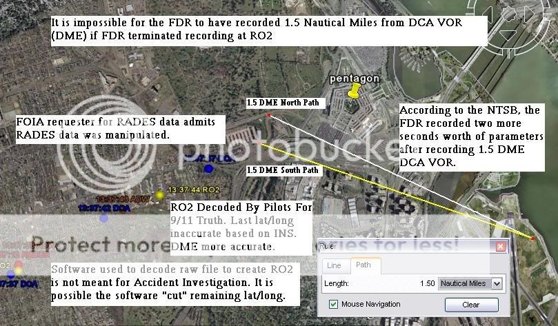
1. Farmers plots above are using a RO2 which was decoded by P4T in which Farmer has been told time and time again the software used for the decode was not meant for Aircraft Acident Investigation. He chooses to ignore such an issue.

2. Farmer fails to provide the last two data points of AA77 in the RADES, of which both are inside the 1.5 DME arc.

3. Farmer has found alterations in govt provided data. He claims it as "Fact" and is not "debatable anymore". Now he uses P4T decoded data in which he has been told cannot be used and which P4T doesnt even use themselves?

4. Lat/Long is 3000 feet in error at IAD runway 30 for RO2. It does not match the "official flight path of AA77".

5.
RO2withDMEText.jpg


Have a great night.
 
John Farmers work on the animation alterations. Google is your friend :)

Note: External images are gone since Farmer nuked his blog.


http://www.abovetopsecret.com/forum/thread284390/pg9

you posted Balsamo’s failed interpretation of the NTSB animation and how he ignores the FDR information proving his failed ideas are such.

This is the birth of the dirt dumb NoC; a blunder by Balsamo the terrorist apologist. Great history lesson, thanks

Balsamo states this as his fact, but I forgot he has no clue, no theories --- Summary - The animation heading (instrument reading) was altered to show a southern approach. If the heading wasnt altered it would show 090 Mag or 080 True. Just as the plot shows to the north of Citgo.
Balsamo says the stuff! Balsamo promotes stupid ideas using other people as his foil. I forgot Balsamo has no clue and no theories. But he said the heading was altered! Sorry, he always messes up and makes a theory, and acts like he has clue but he is always wrong.


I forgot he was selling dvds and implications of lies.
 
Last edited:
you posted Balsamo’s failed interpretation of the NTSB animation and how he ignores the FDR information proving his failed ideas are such.


Actually Beachnut, JDX quoted Farmers "failed interpretation of the NTSB animation" on ATS. I just re-quoted it here.

Did you miss the link at the bottom of the original quoted text on ATS? Its http://911files.info/blog/?p=101.

Unfortunately, i cant source it directly to Farmers blog due to the fact those pesky P4T and CIT members "cyber attacked" it (according to Farmer). :rolleyes:


Get some sleep Beachnut, you must be tired. You are unable to determine where the orginal quote came from.

Sleep well... :)
 
1. Farmers plots above are using a RO2 which was decoded by P4T in which Farmer has been told time and time again the software used for the decode was not meant for Aircraft Acident Investigation. He chooses to ignore such an issue.
9/11 was not an accident investigation; what can you be talking about.


The data from p4t matches the NTSB, but p4t decode rounds different, and is missing data, and a second of decode at the end. Plus they post a DME for every second. Errors. But the data can be used for refuting Balsamo.

2. Farmer fails to provide the last two data points of AA77 in the RADES, of which both are inside the 1.5 DME arc.
The last two data points of RADES was not 77! ... why show you have no idea what it means? 1.5 DME is not the actual distance from DCA due to many factors Balsamo does not understand.


3. Farmer has found alterations in govt provided data. He claims it as "Fact" and is not "debatable anymore". Now he uses P4T decoded data in which he has been told cannot be used and which P4T doesn’t even use themselves?
He has not proven that fact yet. So? What data is wrong? Post it. P4t don’t use anything to make up their failed ideas, I agree with you.


4. Lat/Long is 3000 feet in error at IAD runway 30 for RO2. It does not match the "official flight path of AA77".
No, the INS is off at take off, not the Lat and Long (77 was really on the runway, the INS is only so accurate, it all works out, but then what can you expect from Balsamo). So? The INS does match the “official flight path” you are having problem comprehending what the FDR records and what it means.


You do understand the plane flew an actual path that is represented relatively correct by the FDR, but the accuracy of an INS in 77 could be thousands of feet off in accuracy. Truth is too hard to understand, go to flight school and learn how these things work, do not use the one Balsamo went to.

Don’t forget the INS is updated and drifts during flight. The position can be better at the end.

You better wait for Farmers final paper before jumping on anything you have from farmer in the past. Things have changed.


It is not impossible for the FDR to stop recording over 6 seconds away from the Pentagon with 1.5 DME recorded in the FDR. The FDR stores DME at a resolution of 0.25 NM, and the practical accuracy of DME where 77 was flying is at best 0.23 NM or worse. These errors alone allow 1.5 DME to be stored yet 77 is over 1.7 NM from DCA when 1.5 DME is stored. But I am only an experienced pilot heavy jet; and as an engineer I know modeling the errors in the DME from thwho flew left seat heavy jets in my twenties, Balsamo may never make it to the left seat e FDR allows 77 to be over 6 seconds away from the Pentagon and 1.5 DME is stored in the FDR. But a masters in engineering is all I have, maybe your p4t experts can model the DME errors and explain why I am wrong. They can’t. Why?

 
Last edited:
I can’t read the post in question, so I’ll just go by the comments here and memory. This is Mr. Balsamo’s retaliation for my verification of the RO2 file after 2 ½ years of research into the NTSB data. In response, he posts brainstorming I did 2 years ago when he and the kooks at P4T were my “experts” in aeronautics. Unfortunately, most people here do seem (as then) want to get hung up on a simple equation put together for laymen to attempt to express a rather complex subject (something I have not been very adept at doing).

The phenomenon discussed at that time was irregularities in the NTSB data files. It began with a thought model. What would be the impact of increasing the heading in the files artificially? Draw a box grid and without changing the beginning heading of the path, change the number of degrees of the final loop to increase the final heading and end up at the same point. Attempting to keep the model as simple as possible, I used d (you can use any notation you desire in simple models) for distance so math-illiterate people would not scratch their heads at what s means (math for dummies).

Prediction results of the model based on d (distance traveled) traveled in the same time (can’t change the time of departure or time of impact), required that the box shrink and offset. What is seen in the CSV file? The latitude and longitude is shifted. Also, there would be a shift in lateral acceleration when plotted against heading which would be abnormal. What is seen in the FDR and CSV files? The lateral acceleration is shifted in relation to heading. Now we can debate this all day long, but that is the data in the CSV and RO2 files. If arguing over d versus s makes some feel better, then that is fine, but it does not address the observed shifts in the data.

As I noted in yesterday’s thread, I have listened to a lot of “experts” over the years. It did not take me long to figure out that the “experts” at P4T were giving me bad advice. I approached them due to my lack of knowledge in the field of aeronautics.

My position then, as now is that there are some serious issues with the NTSB data set. Where I parted ways with P4T is that it did not take me long to realize that a negative shift in vertical acceleration results in a positive heading change. In other words, any shift in lateral acceleration would be result in a POSITIVE apparent heading change, not a negative one to decrease apparent heading (the premise of this thread). Like I said before, that is why I don’t brain-storm on blogs or forums any more, because people (like Rob) like to go from modeling to conclusion without the intermediate steps of gathering data and disproving models. Now, if you guys wish to accept the premise that three data sets produced to represent the same data set with wildly different results is some kind of accident, then perhaps math and science are not your best career choices.

Are the files tampered with? I don’t know and we’ll just have to wait for the data to be released in order to resolve that issue. Perhaps they are calibration issues and the NTSB is simply incompetent. That seems to be the leading theory here at JREF. All I know is, I’ve talked to some real experts since I began my project and I still don’t have the answers and nor do they.

Nice counter-attack P4T :)
 
Last edited:
It was adjusted for true north, but whoever adjusted it rotated it the wrong way. It's been discussed to death here, welcome to 6 months ago!

If the magnetic declination was adjusted the wrong way (which would account for the end heading being 20 degrees off), then why was it correct at the beginning of the animation when it departed Dulles? What changed from the beginning of the animation to the end to reverse the magnetic declination value's sign?

I pesonally think the issue is moot, but I have yet to hear a valid hypothesis.
 

ISF - Join now!

Every member here is approved by hand. No bots, no spam, just people who care about evidence and honest debate.

Membership is free!

Create your free account

Back
Top Bottom