Given that the clip covers about 3.5km of travel
Just over 3.1. Why is every single value you state always wrong ?
and is seen from nearly end on it gives a highly exaggerated view of any orientation changes
Not
exaggerated, but certainly blatant. You have to be careful to interpret correctly, sure. Exaggerate ? Nah.
From that angle, that's what a 3-4° turn looks like.
Angle ? Methinks you are forgetting a dimension or two. You don't appear to have even bothered to determine the camera location. I'm afraid you have to do more than assert, you have to show why

With the radar tracking the aircraft at an initial 18° orientation relative to the towers the turn in at the second to last radar marker placed the aircraft at about 15°.
Radar tracked the aircraft at an initial location in a different city !!11!!

Assuming you mean the radar image provided, which covers significantly more than the last 3km of travel, why is it that you are incapable of sourcing any of your own data ?
Assuming you mean the angle change from a top-down viewpoint over the period of time of the provided animated GiF
using only the available radar datapoints (which do NOT get you to the towers and do not include the last moment manouvers) then you're looking at about 1.5 degrees, not 3 degrees.
Why are all your values so shoddy ?
A last minute turn isn't going to get him an extra 11.5°.
A baseless assertion I'm afraid. You are also neglecting a number of dimensions.
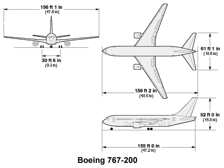
Since I had a 1/200th scale 767 in the kit pile
I'm sure you did

Did you bother to scale it correctly ?
Did you bother to apply appropriate dihedral wing angle ?
and a couple of hours to spare I threw together a scale model of the scene.
CLEARLY thrown together. Absolute joke given the kind of criticism you've aimed at my clearly far superior and proficient "efforts"

Locations and angles are as per the 2d maps used to draw the sightlines.
Sightlines ? Say what ?
Do you mean that you are using the high resolution satellite map, that I provided you with, as a plane within your renderering package, positioning scaled models of the WTC complex over such, setting up an appropriate camera placed correctly over the same image, determining focal point projection and aiming the camera as appropriate ?
Or do you mean you botched together a couple of measurements and placed objects with no ability to verify relative positioning or scale ?
I strongly suspect the latter, which would be attrocious.
WTC building stand ins are at 29° relative to a north south baseline and all scale distances are measured off that datum line.
Clearly you are not using the provided satellite imagery to define relative position between scene objects. Pfft.
NIST model was at 12° yaw angle and 5° nose down pitch
I strongly doubt your ability to remember to specify all aircraft orientation changes in aircraft axes, not world axes...
Your "renders" are an absolute joke.
It's not often I'm so blunt...
You haven't bothered to include secondary buildings, for a reason.
That reason is one of the following two options...
1) You are not competent to perform a simple rotoscope accurately.
2) You are fabricating results... aka lying.
Now, given that I performed my rotoscope with clearly far more care, and have absolutely zero reason to fabricate results...I'm afraid I suggest you are suffering from BOTH (1) AND (2) above.
That you get a result that NIST is "spot on" and femr2 is "wrong" I KNOW you've messed up.
Ending up with NIST "correct" is so blatantly dry-labbed it's hilarious.
Given that there's nothing wrong with my previous method I find your criticism of it absurd and baseless.
Of course there's something wrong with it, as I have explained to you several times.
It CANNOT capture off-plane angular changes. It cannot "work". It's fatally flawed for the purpose you are applying it to.
Since I had the model there here's a visual for you
An unreadable garbled image. Learn to use the tools first.
regardless of whether the aircraft is being viewed from ground level or from the impact level it has the same proportional nose to tail distance. The only thing that changes is the diagonal.
Oh dear.
This is
getting ridiculous.
I'll get around to finding the box with the original scene files, or simply regenerate them.
Provide your scene files please

I can then detail all of your failings in full.