LAL
Illuminator
- Joined
- May 19, 2005
- Messages
- 3,255
In LAL's quoted post above mentioning Whitehall and it's population she originally said 'check to the west' as opposed to the edit of 'check what's around the town'.
I changed it after noticing the area to the east isn't necessarily farmland. Google Earth isn't all that detailed and I'm not used to it. I'm not sure just how the Adirondacks run and Google is timing out on me. I'll check Topo.
This report mentions a tree farm.
"ENVIRONMENT: I've mapped the area by natural community 'cover types'. Essentially, the forested areas are Beech-maple mesic forests with scattered occurrences of the Hemlock-northern hardwood forest community, particularly on western and northern slopes. Lesser occurrences of the Pitch pine-oak-heath rocky summit community are found near ridge and hill tops dominated by rock outcroppings.
http://www.bfro.net/GDB/show_report.asp?id=9723
From my friend's photos, I know the area they were in was remote and wild as anything around here................just smaller. They not only heard wood-knocking, it was in response to theirs.


") The still is also from his presentation.
The still is also from his presentation.

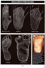
 Where do get that? Anyway it's hard to forget they're almost twice the width of ANY primate dermals.