You are using an out of date browser. It may not display this or other websites correctly.
You should upgrade or use an alternative browser.
You should upgrade or use an alternative browser.
Michael Shermer vs. "alternative history" Hancock and Crandall
- Thread starter angrysoba
- Start date
King of the Americas
Banned
- Joined
- Nov 15, 2001
- Messages
- 6,513
Your lines only appear oh the trees at a certain resolution. They are not there when zoomed in or out. They go straight over hills and mountains.
They are artifacts resulting from the way Google renders the images.
Nope...that's what I thought too.
I can show you:
When you pull in and out they appear in a range from like 10,000 feet up to 50,000'ish.
Think of it like an 18 hole golf course. If I blind folded you, and plopped you down at the far edge of a dogleg you might think you were just in a nicely manicured park, only from above or with more exploration could you see you were really on a golf course...but after you escape 50,000, it's all just tree forest with no breaks. Some things are only visible from a certain height, and these end where big river basins pass.
Attachments

Last edited:
King of the Americas
Banned
- Joined
- Nov 15, 2001
- Messages
- 6,513
This is one ridiculous thread. His claims are all over the landscape, and he does not hesitate to contradict himself back and forth.
Someone PM me if we ever get back to the beer thing. I once had a recipe for beer made from Kellog's corn flakes. Is that evidence that Kellog's of Battle Creek financed the construction of Gobekli Tepe? Hmm?
Headed back to denial? And I ain't talking Egypt!
King of the Americas
Banned
- Joined
- Nov 15, 2001
- Messages
- 6,513
Fascinating. Can you set out Plato's claim in Classical Greek and walk us through your alternative interpretation?
That will generate much laughter.")
I think Plato's tale doesn't take into account the geography of Africa, before this tsunami.
If you look at north africa it looks like a poop-ton of sand came out of the Mediterranean and poured out across the Sahara and through the pillars, then turned south east. Before this sand dump, the Straights and the Pillars had different water passages.
A volcano opposite the wash erupted and or landslid into the sea...I predict, that if we look, we can find and date the volcano that destroyed Atlantis using this sand wash.
Last edited:
John Jones
Penultimate Amazing
I think Plato's tale doesn't take into account the geography of Africa, before this tsunami.
If you look at north africa it looks like a poop-ton of sand came out of the Mediterranean and poured out across the Sahara and through the pillars, then turned south east. Before this sand dump, the Straights and the Pillars had different water passages.
A volcano opposite the wash erupted and or landslid into the sea...I predict, that if we look, we can find and date the volcano that destroyed Atlantis using this sand wash.
Another woo-laden, fact-free post with a built-in burden of proof shift (highlighted).
King of the Americas
Banned
- Joined
- Nov 15, 2001
- Messages
- 6,513
Another woo-laden, fact-free post with a built-in burden of proof shift (highlighted).
No, that's how "science" works.
You look at evidence, form a hypothesis, test it, THEN make a prediction.
I 'predict' I will find a volcano, and date its eruption by following this sand wash.
TheSupermeerkat
Graduate Poster
- Joined
- Nov 12, 2015
- Messages
- 1,776
No, that's how "science" works.
You look at evidence, form a hypothesis, test it, THEN make a prediction.
I 'predict' I will find a volcano, and date its eruption by following this sand wash.
You’ve repeatedly shown yourself to be colossally ignorant of every subject you’ve touched upon in this thread, and here’s another shining example of it.
You don’t understand “science” then, as peer review and falsifiability are a rather important part of it. Your peers reject your claims, and your claims can be easily be shown to be something else (e.g. image artefacts).
John Jones
Penultimate Amazing
No, that's how "science" works.
You look at evidence, form a hypothesis, test it, THEN make a prediction.
I 'predict' I will find a volcano, and date its eruption by following this sand wash.
I neither need nor accept descriptions of the scientific discipline from pathologically credulous lay persons.
Gamolon
Master Poster
- Joined
- Dec 6, 2006
- Messages
- 2,702
I'll repeat my question.I repeat, these lines disappear where rivers washed them away.
Are the grayish, almost horizontal lines pointed at by my red arrows in the picture below the "plow lines" you are referring to?
Gamolon
Master Poster
- Joined
- Dec 6, 2006
- Messages
- 2,702
Pretty funny!Yes.
These lines represent the fact that the African rainforest was plowed before it was planted.
Your image:

Link explaining why there are lines:
https://www.gearthblog.com/blog/archives/2016/11/new-landsat-sentinel-2-data-google-earth.html
In many locations you will notice narrow stripes in the imagery. This is because of a faulty part on the Landsat 7 satellite. Learn more about it in this post.
The mosaics are created by trying to select imagery from throughout a given year then selecting cloud and snow free pixels where possible. However, there are a few locations on earth that are almost always cloudy, a problem we discussed in this post.
They even give an example photo of these lines:

Both your "plow lines" and the "narrow strips" match up.
Go figure.
King of the Americas
Banned
- Joined
- Nov 15, 2001
- Messages
- 6,513
You’ve repeatedly shown yourself to be colossally ignorant of every subject you’ve touched upon in this thread, and here’s another shining example of it.
You don’t understand “science” then, as peer review and falsifiability are a rather important part of it. Your peers reject your claims, and your claims can be easily be shown to be something else (e.g. image artefacts).
You are not my peer, and I reject your analysis.
King of the Americas
Banned
- Joined
- Nov 15, 2001
- Messages
- 6,513
Pretty funny!
Your image:
[qimg]http://www.internationalskeptics.com/forums/imagehosting/thum_134095a2167fd5058a.jpg[/qimg]
Link explaining why there are lines:
https://www.gearthblog.com/blog/archives/2016/11/new-landsat-sentinel-2-data-google-earth.html
They even give an example photo of these lines:
[qimg]http://www.internationalskeptics.com/forums/imagehosting/thum_134095a21688963465.jpg[/qimg]
Both your "plow lines" and the "narrow strips" match up.
Go figure.
This is NOT what's happening:
The lines stop at the river...
Attachments


King of the Americas
Banned
- Joined
- Nov 15, 2001
- Messages
- 6,513
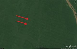
I'll repeat my question.
Are the grayish, almost horizontal lines pointed at by my red arrows in the picture below the "plow lines" you are referring to?
[qimg]http://www.internationalskeptics.com/forums/imagehosting/thum_134095a202c723b231.jpg[/qimg]
Yes, but that's a bad example, as those lines aren't interrupted by a large river.
King of the Americas
Banned
- Joined
- Nov 15, 2001
- Messages
- 6,513
I neither need nor accept descriptions of the scientific discipline from pathologically credulous lay persons.
Credulous or incredulous?
When faced with facts what IS one to do???
Gamolon
Master Poster
- Joined
- Dec 6, 2006
- Messages
- 2,702
Sorry, but you are wrong.This is NOT what's happening:
The lines stop at the river...
The lines in your photo:
Match the lines exactly in the Landsat photo:
They are at the same angle and width yet YOU want them to be "plow lines". Why can't you just admit you are wrong?
TheSupermeerkat
Graduate Poster
- Joined
- Nov 12, 2015
- Messages
- 1,776
Credulous or incredulous?
When faced with facts what IS one to do???
What you call facts, everyone else called lies or claptrap.
King of the Americas
Banned
- Joined
- Nov 15, 2001
- Messages
- 6,513
Sorry, but you are wrong.
The lines in your photo:
[qimg]http://www.internationalskeptics.com/forums/imagehosting/thum_134095a202c723b231.jpg[/qimg]
Match the lines exactly in the Landsat photo:
[qimg]http://www.internationalskeptics.com/forums/imagehosting/thum_134095a21688963465.jpg[/qimg]
They are at the same angle and width yet YOU want them to be "plow lines". Why can't you just admit you are wrong?
BECAUSE YOU ARE USING POOP-POOR IMAGES!
Attachments

King of the Americas
Banned
- Joined
- Nov 15, 2001
- Messages
- 6,513
What you call facts, everyone else called lies or claptrap.
Admittedly, "Skeptics" are a tough crowd.
King of the Americas
Banned
- Joined
- Nov 15, 2001
- Messages
- 6,513
BECAUSE YOU ARE USING POOP-POOR IMAGES!
WHY don't your lines appear across this whole image???
HMMMMM???