Winter starts at the end of December and lasts until the end March
Not in regards to what we are discussing. Meteorological winter is defined as the three coldest months throughout the winter, or December 1st through March 1st. Educate yourself before trying to teach others.
According to your reference there is an trended increase in NH snow cover in December, January and February and generally declining trends March through September.
What reference? And I assure you none of the scientific sources belong to me in any way. All the sources of snow data show the same thing. I covered this in detail last year.
What isn't apparent, is what significance you attach to this?
You probably just forgot. It was explained in great detail.
We can demonstrate that it isn't relating cooler temperatures over the NH in the same periods neither monthly, seasonally, nor annually.
Then demonstrate it. Show us what you claim is happening. This absurdism that somehow, the winters are getting warmer, but at the same time the extent and amount of snow is increasing. I would love to see this. Because it's just not possible. Shucks, if it was, I'm pretty sure somebody would have already done it, just to shut me up and make me look like a total fool. You know? I first pointed it out last winter, which seemed to be pretty bad. But my oh my, this one has turned out to be the worst ever.
After one of the coldest winters on record
Which planet was that?

Now in 2010, you could be excused for not knowing, but in 2014, you might realize that while 2009/10 was epic bad, this year really drives home the facts. Winters in large, important areas of the NH are getting worse. This was true when I said it in 2013,
it's even more true now.
"Subzero Temperature Days Reaching Record Levels in Midwest"
That's a really hard record to beat btw. None of this should be a surprise, as scientists and researchers, who became alarmed after the 06/07 disaster, started looking for reasons, and really became concerned after the 2010 crisis. The winters have never let up since.
While I was going through some of the great links in Macdoc's sig line
http://www.macmagic.ca/ubbthreads.php?ubb=showflat&Number=45753#Post45753
I stumbled across a nice explanation of why the US can expect to experience severe winters, especially in the eastern states. I think the graphs and illustrations may be helpful in countering the climate change denial associated with the colder winters occurring in the US.
From
http://www.arctic.noaa.gov/future/impacts.html
"This dome of warm air and elevated atmospheric pressure surfaces over the pole changes the Arctic atmospheric wind patterns, allowing outbreaks of cold Arctic air to the south."
also
"United States has more severe winter storms
Preliminary results from numerical computer simulations indicate that the significant cold anomalies over the eastern US in winter are associated with the decrease of the Arctic sea-ice cover in the preceding summer-to-autumn seasons (Figure 4, right).2
Although there is considerable year to year variability, as summer Arctic open water area increases over the next decades, an increasing influence of loss of summer sea ice on northern hemisphere wind patters can be anticipated, with resultant impacts on northern hemisphere weather"
All this from the "Future of Arctic Sea Ice and Global Impacts"
http://www.arctic.noaa.gov/future/
They updated the page/info here in Jan 14
http://www.pmel.noaa.gov/arctic/atmosphere/polar_vortex_2014.html
This winter in the US is no surprise to me, just like last year was no surprise. The trend clearly shows colder winters, which is always associated with more snow. Always. In a continental climate cold is directly associated with snow. Only deserts and areas isolated by mountains can experience extreme cold with out the associated snow and ice. Like the interior of Antarctica, or parts of the arctic regions in winter.
As for the nonsense about "increased moisture", that is easily debunked by looking at the precipitation records.
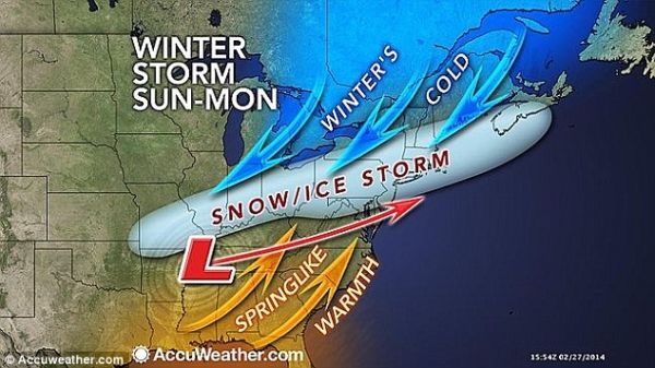
It doesn't matter how cold a high pressure system is, if it meets a low, there will be snow. If it's an ocean fed low, like we see driving winter storm Titan, there will be lots of snow.
If US temperatures were "normal" right now, we would be seeing the front farther north, and there would be more thunderstorms and tornadoes, instead of a blizzard. The huge dome of high pressure, which is really really cold, is the source of the snow and ice.
The Pacific ocean is the source of the warm moist air that is feeding Titan. This is basic meteorology. Learn some before you say another thing about weather.
Even a cursory look at a synoptic map will show you why it's not Gulf moisture and warmth feeding this blizzard.