• Security incident: ISF was recently accessed by intruders. Please change your password, and change it anywhere else you used it. Read more

Merged Mercator projection to be phased out?

Out of the eight or so billion people on earth, what percentage do you think look at a map and consider the scale, instead of thinking " OMG, Greenland is almost as big as Africa !" ?
Worldwide? No idea. At the UN? Probably 0%.

An easier question might be, "How many do you think know what 'latitude' means?".
At the UN? Probably 0%.

Like I said, the UN is the perfect venue for this kind of thing. This kind of thing is pretty much the entire point of the UN.
 
Someone has pointed out that the map they showed has Crimea in Russia. 😡
Which is more than sufficient reason to reject the proposal outright, and point and laugh at the (metaphorically) small peepees of the Togolese delegation. Let them come back and try again when they're not too busy being Moscow's butt-puppets.
 
I don't think anyone is under the impression that the UN is banning the use of the Mercator projection by anyone, anywhere.

This is just a resolution that the UN won't be using it anymore for UN publications and such, swapping it out for a projection that's more uplifting and separating for the African membership.
 
Are you parodying the South about the old projection or the North about the new?
I'm accusing the Togolese of wanting a cosmetic change that will make them feel both more important and literally bigger. And yes, I'm insinuating that their feelings of worth are caught up in primitive and barbaric ideas of manhood and big dick energy. This is the kind of request Donald Trump would make.
 
Last edited:
I'm accusing the Togolese of wanting a cosmetic change that will make them feel both more important and literally bigger. And yes, I'm insinuating that their feelings of worth are caught up in primitive and barbaric ideas of manhood and big dick energy. This is the kind of request Donald Trump would make.
You're doing the same thing about not wanting the new projection.
 
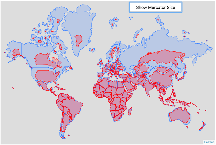
A fun tool to see the 'real' sizes, relatively speaking.

(It explains how Great Britain can be 9th on the list of largest islands even when those Arctic ones seem so vast)

It is interesting that only the northern hemisphere countries seem to have their areas/sizes exaggerated by the Mercator Projection. The size of Africa, South America and Australia/NZ are hardly affected at all in the Real Size Projection.

Seems to me Togo have a fairly valid point in that regard.
The resolution describes correcting such distortions as an act of “cognitive justice and memorial reparation” and points to Equal Earth, developed in 2018, as a projection that more accurately represents relative size.

Mr. Dussey [Togo’s foreign minister] emphasised that the effort was not meant to condemn Mercator, whose usefulness for navigation he acknowledged, or to impose a single projection.

“A fair map does not change the geography of the world, it changes how we see the world,” he said.
 
"We have a map that is scientifically, mathematically, and topographically correct. But it makes us feel like our peepees are smol. Please help."
Way to infantilise the argument.

Mercator served a very useful function once upon a time. Those times are over, and nobody needs those straight lines to navigate now that we've got global GPS. Mercator is entirely redundant. We only hold onto it because of tradition, and because the alternatives freak CJ out.

And it's also Eurocentric. And whether that's a problem depends on whether you believe that Eurocentrism is fundamentally and definitionally racist.
 
One of the issues ships had in the 19th century was how to get from South Africa to Australia? Look at a mercator map and the answer is easy. Just go around South Africa and then head east. Made nagivation easy. However that is not the shortest way. The shortest way is to go south east, then slowly go further east until you are half way there and very far to the south then slowly turn the ship to the north. That is what modern cargo ships do. The main issue with this is that it makes for hard nagivation.
 
It actually makes me mad. There is climate change, hunger, war .. but sure, UN has to solve stupid things like this.
Every country uses its own projection, optimized for their needs. World already has perfect projection. It's called a globus. And guess what, google maps use it. Mercator won't go away, as it has its uses. Just complete nothingburger.
 
Way to infantilise the argument.

Mercator served a very useful function once upon a time. Those times are over, and nobody needs those straight lines to navigate now that we've got global GPS. Mercator is entirely redundant. We only hold onto it because of tradition, and because the alternatives freak CJ out.

And it's also Eurocentric. And whether that's a problem depends on whether you believe that Eurocentrism is fundamentally and definitionally racist.

You could always give her some goldfish.
 
It actually makes me mad. There is climate change, hunger, war .. but sure, UN has to solve stupid things like this.
Every country uses its own projection, optimized for their needs. World already has perfect projection. It's called a globus. And guess what, google maps use it. Mercator won't go away, as it has its uses. Just complete nothingburger.

The UN seems to think this projection will change people's perceptions of climate change, hunger, war by reflecting the disparities between the global north and south. They have a point.
 
It actually makes me mad. There is climate change, hunger, war .. but sure, UN has to solve stupid things like this.
Every country uses its own projection, optimized for their needs. World already has perfect projection. It's called a globus. And guess what, google maps use it. Mercator won't go away, as it has its uses. Just complete nothingburger.

Yeah, why bother to actually do anything when there is climate change, hunger, and war?
 
It actually makes me mad. There is climate change, hunger, war .. but sure, UN has to solve stupid things like this.
Every country uses its own projection, optimized for their needs. World already has perfect projection. It's called a globus. And guess what, google maps use it. Mercator won't go away, as it has its uses. Just complete nothingburger.
I remember a story, possibly apocryphal, about an American showing a world map to a Japanese native, with the US featured centrally. The person tapped on the center of the map and said "On map in my country, Japan here."
 
When I was a kid, it always seemed to me that Greenland was much bigger than Australia, even though our teachers said the opposite was true. Which was why I went down to the library and looked at a globe.
 

ISF - Join now!

Every member here is approved by hand. No bots, no spam, just people who care about evidence and honest debate.

Membership is free!

Create your free account

Back
Top Bottom