Flight 77 Animation

As for the simulation video (which I just saw right now as it wouldn't play the first time I visited the thread), I agree that the reconstruction is awesome and the comments are from somebody talking through his hat.

I think you are aiming too high...

Because the dive would have ripped his wings off. This is not a dive bomber. He evidently flies along not entirely sure of his position, although his course is dead on. This is typical of setting a gps course and watching visually for his target. Suddenly he spots it right under his nose.

And realizes he is way too high up. So, what to do with a big plane like that? You take a big turn and descend...

Exactly what you would expect from a relatively inexperienced pilot.

I assume he is more concerned about flying towards what he must be imagining as his personal gate to Heaven. However, he has no choice but to go around to bleed off altitude, so his concerns don't matter.

He wants to get down there. What he doesn't want is to hijack a plane for a big suicide mission and then miss. Baaaad idea, man....

As we now know they were racing to the scene, but I don't expect that ordinary defence readyness included bogies turning up deep in US territory before 9/11.

They didn't. NORAD's objectives were not aimed at interior threats at the time.

Not really. OK, he delivers the goods, but that is one bumpy ride. I wouldnt let him fly my plane if his turns were that wavey.

It is! Look at the insecure way he handles the plane. Waaaay! Yaaaay! Up! No, correct the plane! Heeeey! Away we goooo....

For all we know he was anxiously scanning the skies. That would account for some of those jerky stick movements.

Absolutely. Or, that he was inexperienced. Nervous? Heck, who wouldn't be? Having last minute second thoughts? Perhaps.... Point is, there are many explanations of his flight pattern, none of which involves a huge gubmint conspiracy.

Mmmm, however, since we observe that the light poles were indeed hit, then we must assume that he was somehow low enough to do just that. This is one of the stupidities of these CTers: They just grab at whatever straw to make things look suspicious. He just implied that the plane was flown by an experienced pilot who knew that interception would be held back. Apart form the obvious question as to just who this pilot is supposed to have been, what is with the lamp posts? Does he imply:

- That they were toppled sometime later to support the notion that the plane had hit the pentagon? (as if the hole in the wall, the fire and the heaps of airplane parts were not ample evidence).

- That they were rigged in advance because the to be suicide pilot told them during the briefing "OK, I can take out the Pentagon, but those lamp posts are a bit of a tall order".

- That they had nothing to do with the attack but were knocked down by a drunken driver the previous night and only noticed after the attack?

:nope:

Hans

This truly shows the desperate state of the CT'ers: If he wants to point to the plane being too high, he has already rejected all his previous points about the plane not being hijacked, being present there, etc. He has accepted that the plane is there, only it is a little too high up.

OK, then: WHAT THE HELL HAPPENED TO THE PLANE, IF IT DIDN'T HIT THE PENTAGON?

I can't wait to hear that one...
 
Anyone want the full FDR csv-file, it's at http://www.hostfiles.org/download.php?id=EC33C56C.

ETA:
Calculating density altitude from the data in FDR and weather data from http://www.wunderground.com/history/airport/KDCA/2001/9/11/DailyHistory.html

...Then again, I'm not sure where this file originated, who uploaded it or if it is unaltered

Alt: 173
Altimeter setting: 29.92
Temp: 73
Dew point: 57

Gives Density altitude: 1324 feet

Well, a similar file can be downloaded from 911Myths, and that file was obtained via FOIA from the NTSB. The header specifically states that its from AA 77

# American Airlines Flight 77 Pentagon
9/11/01 Boeing 757 N644AA
Revision: January 28 2002 January 29 2002
National Transportation Safety Board


The csv file from 911myths shows the #2 altimeter set at 30.23 when the recording stops. 2 seconds before this, the #1 altimeter shows 30.24. Its kind of hard to follow because the baro samples every 4 seconds, and the readout every 2 seconds alternates between the #1 and #2 BAR CORs.


09:37:42,1.401,0.163,-0.042,307,69.6,453.5,99.9,99.1,1.1,-5.3,......,30.24
09:37:44,0.663,0.132,0.031,173,70.0,463.0,99.5,98.8,6.3,-4.9,,......,30.23

If you follow the progress of the baro selectors, you'll find they change for the first time at 09:24:16 passing through 18,000.

09:24:12,1.016,-0.049,-0.003,18205,90.0,329.0,40.4,41.1,0.0,-1.9,......29.91
09:24:16,0.989,-0.051,-0.003,18049,90.0,328.0,40.2,41.0,0.4,-1.9,......30.23

In 4 seconds time, the #2 BAR COR changed from 29.91 to 30.23 and stayed there. However, the #1 changed a bit more slowly and jumped around around before staying on 30.24.

09:24:14,0.998,-0.051,-0.003,18126,90.0,328.5,40.2,41.1,0.4,-1.9,........29.92
09:24:18,0.995,-0.049,-0.005,17972,90.0,327.5,40.1,40.9,0.4,-1.9,........30.01
09:24:22,0.984,-0.049,-0.005,17815,90.0,326.0,40.0,40.8,0.0,-1.9,........30.07
09:24:26,0.975,-0.049,-0.003,17653,90.4,325.0,39.9,40.6,0.0,-2.1,........30.29
09:24:30,0.982,-0.049,-0.001,17482,90.4,326.0,39.8,40.5,0.0,-2.3,........29.97
09:24:34,0.995,-0.049,-0.005,17308,90.4,326.0,39.6,40.4,-0.4,-2.3,.......29.99

....................

09:24:46,1.002,-0.051,-0.001,16787,90.4,329.0,39.4,40.1,-0.4,-1.9,.......30.24

I cant make heads or tails of this. I guess for some reason or another both the left seat and right seat hijackers set their altimeters and Hanjour apparently fumbled around with it before setting it correctly. But, I dont think this has any bearing on the FDR pressure altitude, as you noted.

An even more peculiar thing then strange alt readings is probably that the planes location the last second is recorded as N38°52' W077°25'. Kinda weird since that is some 20 miles west of Washington.
Wow, I didnt catch that. Inertial Reference Position can be fairly inaccurate, but only by a few hundred meters and thats if its not updated through the Nav/ILS receivers.

Another peculiar thing is the absence of radar altimeter data. In the appendices for the 911Myths file, it clearly stated that the LRRA data was recorded by the FDR, but it's noticably absent in the plots and the raw file. Sure hope Mr D'oh isnt reading this thread...:)
 
Anyone else find something a bit odd?

First it was PROVED that it wasn't AA77 flown by hack-pilot Hanjour, because of the "fighter jet-like" turn and descent that only a super-pilot could perform.

Now they want us to be suspicious because the turn was so slow and lazy?

Ack.

-Andrew
 
Okay, here's how to disprove the 'no street lights' thing.
JD has come up with some very poor science as to why the airliner didn't hit them, based on a heap of assumptions, etc.

I reckon the way to work it out properly is to look at the Flight Data Recorder information then work it backwards from there.
I don't have my notes handy, but I worked out it was doing something like 777 feet per second in the last couple of seconds before it hit the Pentagon. It was also losing about 66' per second.
The street light that was first hit was pretty close to 1,000' from the impact point, and by my calculations that means the top of it has to be about 85' higher than the floor of the Pentagon. Since the poles are 30' high, that means the ground has to be about 55' higher there than the impact point.

It looks like that first pole is sitting on top of an overpass, so the elevation should be very close to that.
Can someone confirm this?
 
Note that using my method, you can completely ignore the assumptions made about what altimeter setting was used, etc.
We know the impact point.
We know the flight path.
We know the distances involved.

From there, it's simple maths.
 
Hey there Bill.
Glad to see you here.
That exchange between you and JDX was my first exposure to the world of LC and the online CT nutters.
I laughed my guts out.
Cheers.
IDAK.
 
Note that using my method, you can completely ignore the assumptions made about what altimeter setting was used, etc.
We know the impact point.
We know the flight path.
We know the distances involved.

From there, it's simple maths.

I wish it was that simple. The problem is that WE know, but THEY don't. They claim that the lamp posts couldn't have been clipped by AA77 since it came in too high (surprise! many of them seem to think that explosives was used to bring down the lamps instead).

Therefore, working backwards doesn't really work to disprove their ramblings.
 
Ladies and Gentlemen, do not worry about it, the position is not near the Light poles,

29.92 is the standard atmosphere over 18000 feet it is referred to as the standard pressure atmosphere.
30.22 is the barometric pressure at the ground station in Washington on September 11.
That means that the Altimeter would read low, and altimeter, would read about 300 ft lower than the aircraft was actually flying.
You can not do an altimeter test unless you are the exact pressure the flight 77 was in.
IT does not matter anyway since the data was lost, for the time past where the plane went over Eleanor C. Lawrence Park.
That is no where near the Pentagon, so the data does not matter if the plane was 10 foot or a thousand the plane is in the wrong position.
The plane could have lost thousands of feet of altitude, before it hit the light poles and the Pentagon, they simply believe that the last recorded data happened at impact, when it did not, the recorder was either shut down or did not record the data. The recorder itself was damaged, is what the statements say.
The loose change assumptions are Fallacy once more.
PS. I stated what I did About Density altitude because I was told by a pilot from an airline that some planes record that from the navigation computer because it tells you more about engine performance.
I believe he was referring to the Airbus now not the 757 a much older plane.
 
The plane could have lost thousands of feet of altitude, before it hit the light poles and the Pentagon, they simply believe that the last recorded data happened at impact, when it did not, the recorder was either shut down or did not record the data.

Actually, the last recorded values (assuming they are correct) shows that at <=1 sec from impact the plane was at most 800 feet from pentagon and a few hundred feet up. I'm trying to figure out why just so I can whack another mole...kinda like a hobby.
 
Last edited:
Actually, the last recorded values (assuming they are correct) shows that at <=1 sec from impact the plane was at most 800 feet from pentagon and a few hundred feet up. I'm trying to figure out why just so I can whack another mole...kinda like a hobby.

The last second position is N38°52' W077°25' Eleanor C. Lawrence park. http://maps.google.com/maps?output=setprefs&near=%2B38%C2%B0+52%27+0.00%22,+-77%C2%B0+25%27+0.00%22

The data recorder was damaged in the crash, the last few minutes are not on the data!

You are using the Ntsb free down load are you not, and not the Loose Change File?

http://www.ntsb.gov/info/foia_fri.htm

If you go to the radar data you might find the flight path data after the FDR data stops.
 
Last edited:
B-Man said:
I'm here now.


It looks like that first pole is sitting on top of an overpass, so the elevation should be very close to that.
Can someone confirm this?

Welcome Bill!

I forgot about the overpass. I' d say that puts the top of the poles about 100' above sea level(37' elevation, 30' poles, 30' overpass). Also, the static data isnt dead on balls accurate either, its got at least 20' of error.

That gets us pretty close to 120' even if the altimeters were set correctly. However, the #1 alimeter was at 30.24, or 0.02 in error - so that gets us even closer and the last second is pretty much a wash because alot can happen in the second between the last recored data and impact. However, thats all assuming that the altitude data is baro corrected.

I'm going to agree with Chainsaw. This can all be resolved by saying that the recording stops when the plane was 450' or so above sea level. That would put it about 7 seconds from impact and 6 seconds from the poles. Maybe the last few seconds of data was badly garbled, and they could only verify up to a certain point, who knows. If the FDR "pressure altitude" is what we are defining it as - thats the only explanation.

If the recording stops at impact, then what the NTSB is defining as "pressure altitude" may just be baro corrected static data. That would make sense as crash investigators would certainly want to know what was displayed on the altimeters.

I also read that most of the data(like radar altimeter data) wasn't included at all, because it was erroneous or "not recorded properly".

http://www.911myths.com/AAL77_fdr.pdf - pg 2.

Crazy Chainsaw said:
PS. I stated what I did About Density altitude because I was told by a pilot from an airline that some planes record that from the navigation computer because it tells you more about engine performance.
I believe he was referring to the Airbus now not the 757 a much older plane.

The engines on pretty much all airliners have their own static and inlet temperature ports that are used soley for engine indicating, thrust rating limits and thrust management. The cockpit altimeters are basically just looking at ambient static pressure from the pitot static ports.
 
The last second position is N38°52' W077°25' Eleanor C. Lawrence park. http://maps.google.com/maps?output=setprefs&near=%2B38%C2%B0+52%27+0.00%22,+-77%C2%B0+25%27+0.00%22

The data recorder was damaged in the crash, the last few minutes are not on the data!

You are using the Ntsb free down load are you not, and not the Loose Change File?

http://www.ntsb.gov/info/foia_fri.htm

If you go to the radar data you might find the flight path data after the FDR data stops.

Not possible. Either the lat/long is wrong or the pressure alt. is wrong. Both cant possibly be correct. There is no way the plane was at 450' that far away. When the 330 degree turn started, AA77 was at 7000'. If you really follow the raw file, you can "watch" the last few moments of the approach. The heading was stable at around 70 degrees(which intersects that particular facade at a 55 degree angle). You can see power increased and speed increases fast as well. At the very earliest, the data stops 10 seconds away..
 
Hey there Bill.
Glad to see you here.
That exchange between you and JDX was my first exposure to the world of LC and the online CT nutters.
I laughed my guts out.
Cheers.
IDAK.

I have heard much about the Billzilla/John D'oh exchange at chez loosers but have never actually seen it - do you know if it is still available for reading there or did they deep six it to eliminate the evidence of JDX's embarrassment?
 
I have heard much about the Billzilla/John D'oh exchange at chez loosers but have never actually seen it - do you know if it is still available for reading there or did they deep six it to eliminate the evidence of JDX's embarrassment?
I believe it was in the Skeptics forum, which is No More.

I've never used the Wayback Machine--would that be able to recover something like this?
 
I have heard much about the Billzilla/John D'oh exchange at chez loosers but have never actually seen it - do you know if it is still available for reading there or did they deep six it to eliminate the evidence of JDX's embarrassment?

It's all gone.
I tried to be funny at times, for the amusement of others reading it and also because I knew he wouldn't understand it. ;)
But they wore me down by weight of numbers and I lost my cool for a while. But they don't bother me now, it's just a laugh.

Hey apathoid, instead of guessing the elevations can we find out for sure? I'm pretty sure the FDR info I have is good down to within a second of impact so I can get some accurate numbers into the elevations required.
 
It's all gone.
I tried to be funny at times, for the amusement of others reading it and also because I knew he wouldn't understand it. ;)
But they wore me down by weight of numbers and I lost my cool for a while. But they don't bother me now, it's just a laugh.

Hey apathoid, instead of guessing the elevations can we find out for sure? I'm pretty sure the FDR info I have is good down to within a second of impact so I can get some accurate numbers into the elevations required.

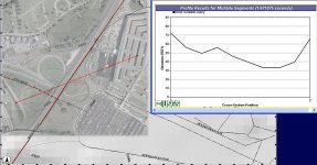
Its even higher than I originally thought. Standby for some USGS screencaps :)
 
I have heard much about the Billzilla/John D'oh exchange at chez loosers but have never actually seen it - do you know if it is still available for reading there or did they deep six it to eliminate the evidence of JDX's embarrassment?

To put it in short terms, Johndoe got owned.

For visual terms, I refer you to this.

ninjacatma7.jpg
 
I'm pretty sure this info is accurate as its from USGS.
http://seamless.usgs.gov/website/seamless/viewer.php

As you can see, the overpasses are plainly "visible". Hope this helps Bill :)

ETA: the elevation rise on the right may actually be the Pentagon itself - I'm pretty sure the building is sitting on a flat spot.. :D
 

Attachments

  • Pentagon elevation2.jpg
    Pentagon elevation2.jpg
    98.6 KB · Views: 27
Last edited:

ISF - Join now!

Every member here is approved by hand. No bots, no spam, just people who care about evidence and honest debate.

Membership is free!

Create your free account

Back
Top Bottom