• Quick note - the problem with Youtube videos not embedding on the forum appears to have been fixed, thanks to ZiprHead. If you do still see problems let me know.

Merged Apollo "hoax" discussion / Lick observatory laser saga

Status
Not open for further replies.
There are no experts to appeal to here.

Actually the experts rendered their verdict just above your post. Your party is over. Well, except that you'll just keep retreating farther into your fantasy world.

Time to stop pretending you can read a map, divide two numbers, or fly a spaceship.
 
For those interested in the history of Geodesy/Geodetics and its impact on Apollo, not to mention vice versa, I just finished reading a book that was so interesting and relevant. I just couldn't wait to pass along what I had learned.


You posted something ridiculously wrong, I easily refuted it with a link to satellite geodesy, and now you're writing a post as if nobody here as ever heard of satellite geodesy. Amazing.
 
Patrick1000 you made an enormous and very basic error in your estimate of the Apollo budget, far from acknowledging it you've simply changed subjects and added fresh errors. Do you understand the mistake you made? If not try looking up the total federal budget for each of those 11 years, add it up, and then compare to the total spent on Apollo in the same time frame, perhaps then you will grasp the error.
 
Actually Tomblvd, I believe the ultimate truth is based on one's own research. I think references like the Smisonian article are helpful, but there is nothing like doing one's own thing under these circumstances, by that I mean in the context of Apollo history research.

Translation; "I'll ignore the parts I don't like."

What you said is no answer at all to why the article is "accurate" when it supports your preconception, but "wrong" where it doesn't.

It is still cherry-picking. And worse; you keep reaching for more and more serious-sounding, surely-you-must-trust-their-professionalism sources, yet you have yet to confront that the problem other people have is not with your sources, it is with your selective quoting (and frequent misinterpretation) of them.

I'll give you an example Tomblvd, and show you why I am so confident in what I do for myself. By that I mean, I'll prove to you yet again, beyond any doubt whatsoever, that Apollo 11 is fraudulent in an absolute sense.

Go to the reference site for the USGA Apollo 11 landing site map;

http://www.lpi.usra.edu/resources/mapcatalog/usgs/

Download the map I previously suggested merited careful study, the 1: 25,000 I-619 composite map of Maurice J. Grolier, published in 1970. Load this map into your photo software and then straighten out the latitude and longitude lines so that they run straight up and down and straight right to left. I found that when I did this it required 12 degrees of clockwise rotation to square the latitude and longitude lines as mentioned.

Now go to the Apollo 11 image library again;

http://www.hq.nasa.gov/alsj/a11/images11.html

Go to the Lunar Orbiter Frame 5076. This of course is an image of the landing site area in its native configuration, native orientation. Download that image, and then load it into your photo software. Once loaded, simply rotate the image 12 degrees counterclockwise.

Now compare that image with the LAM-2 flown map image that Collins allegedly took with him on the Apollo 11 flight. After you play with it for a while, comparing markings, landmarks and so forth, you will be convinced that the LAM-2 map was similarly obtained, perhaps from this very Lunar Orbiter image, or one just like it. That is, the LAM-2 image is an image rotated roughly 12 degrees counterclockwise from the image's native/accurate orientation.

Now, look at the landing ellipse drawn on the LAM-2 Apollo 11 flown map. You will note Tomblvd that the ellipse runs with its long axis east west on this map. But that should not be. It should run east west on an image with the lunar orbiter 5076 orientation. It should run east west when viewed in an unrotated image, not in an altered image such as this LAM-2 12 degrees to the counterclockwise rotated image.

Someone has cheated here and done a good job of it. This is insanely sneaky. The LAM-2 image was first rotated and THEN the ellipse was drawn in, over the 5076 equivalent 12 degree counterclockwise rotated image.

Proof positive of fraud, and we need not consult a soul at the Smithsonian or anywhere else for that matter, though I do believe the Smithsonian "bug" article was somewhat informative.

So the LAM map is fake, rotated and then labeled with an ellipse, 12 degrees counterclockwise out of proper orientation.

Copied and pasted. You insult Tomblvd by assuming he never read your previous post, and the rest of us by filling up the thread with walls of text that have already been posted here before.
 
Sure I have proven it is a fraud Jay, they don't have a bathroom in the spaceship. Game/set/match right there bro.

Ptrick. One of the Gemini missions lasted for 14 days. Without a bathroom. Do you believe that the Gemini missions were also faked?
 
Secrets Of The Apollo 11 Flown LAM-2 Map Revealed

Got to the Apollo 11 Image Library, Landing Site Maps/Images Section;

http://next.nasa.gov/alsj/a11/images11.html#Maps

Scroll down to the CMP LAM-2 Flown Map and click on that. Higher res is always best. Note that in addition to the lettered "latitude lines", there are also lines running diagonally at roughly 12 degrees from the horizontal, left higher than right side of the map with regard to the slope's inclination.

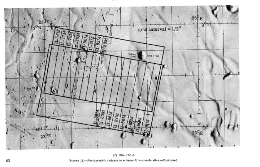
Now scroll up to the 3rd entry in the Map/Image Library, Apollo Zone of Interest. Click on that and recall as I mentioned before, and as is evident in this image, that the lunar orbiter shots of the Tranquility Base Landing Site, II P-6, were taken such that their images in their native/raw setting have upper and lower borders that run 10-12 degrees from the horizontal.

Go to lunar orbiter frame 5076 in the library and note the photo's 10-12 degree from the horizontal clockwise rotation. Note also that were they drawn in, the latitude and longitude lines on this native/raw image would run straight up and down, straight right and left, the image frame slanted, but lat/long lines running straight and without slope from true vertical and true horizontal.

Now the full LAM-2 Map deception is revealed. Look again at the LAM-2 flown Map. Imagine that one could hold the slanted lines running 12 degrees downhill left to right in position and rotate the map under them so that the lettered latitude lines of the LAM-2 Map would run parallel with the slanted lines. One would then have turned the map back to its native/raw orientation, that of the lunar orbiter image 5076 just visited. Note now that under such a circumstance, with this map rotated back to its native orientation, that the landing ellipse would also be rotated and run at 12 degrees to the horizontal. As such, we may conclude the ellipse, as previously mentioned, was drawn, superimposed over the map image AFTER it was rotated so that the long axis of the ellipse would APPEAR horizontal on the LAM-2 Map. Were this a genuine/authentic/scientific rendering, the ellipse would run parallel to the true horizontal on the Lunar Orbiter 5076 image, and once that image was rotated 12 degrees, the ellipse would then run downhill right to left. This is indeed the case with the Grolier Map, the post flight USGS map published in 1970. This is the last of the Image Library maps presented in that library's collection. In the Grolier Map case however, the ellipse image/outline has been removed, but that would nevertheless be its true orientation on that map, downhill, right to left with its long axis exactly parallel with the slanting latitude lines. The LAM-2 Map, being fraudulent, is nothing like this at all.

So on the Apollo 11 Mission LAM-2 Flown Map, the lines that slant left to right downhill at an angle of 12 degrees reflect this image's native orientation. The lunar orbiter took the photo this way when imaging area II P-6. Note now how the "mysterious blue dot" at K .2 and longitude 5.6 of the LAM-2 map makes infinite sense. It lies along a line running up diagonally at about 16 degrees, by my estimation, from "Tranquility Base", close enough to 12 degrees, these things being marked by hand. Tranquility base "moves" from the blue dot down(south) and east to J .65 / 7.52 given the LAM-2 Map is first of all rotated 12 degrees counterclockwise from its native/raw orientation, and secondly, the longitude lines are set up 4 radians west of where they should be.

These guys were not as clever as they thought, leaving some clues, including the tell tale blue dot, and the slanting lines that are running left to right downhill at 12 degrees right across the map. They probably had to for reasons I will discuss later.

Remember, that this is a number's game. They are hiding the simulated location(s) of the Eagle. Actual real life physical landmarks, craters and things, don't move in relation to one another, or in relation to their true coordinates. Once the dust settles, Tranquility Base is just west of Little West Crater, no big deal the perps, the fraud artists, would say.

Fraud, undeniable and inescapable, now revealed in all of its horrendous glory by way of this simple map/image analysis.

Apollo as truth is now dead. Historically, this map has now become more important than Armstrong's once famous, and as of today, infamous words, "One small step....."

Finally, absolute stone, cold, hard proof positive of Apollo 11 fraudulence has arrived. Apollo as "history" will never be the same. All that remains is to discover and disclose the details of the now confirmed charade.
 
Last edited:
I have not studied Gemini Multivac

Ptrick. One of the Gemini missions lasted for 14 days. Without a bathroom. Do you believe that the Gemini missions were also faked?

I have not studied Gemini Multivac. Perhaps I can comment later as I read more.
 
Endlessly repeating the same assertion doesn't make it any better Patrick, especially when your lack of knowledge in the area of cartography has been utterly exposed previously. No one believes your posts because no one believes you understand the topics you keep bringing up.
 
What we have here is, failure to elucidate.....

Got to the Apollo 11 Image Library, Landing Site Maps/Images Section;

That STILL doesn't address any new "research" on your part concerning the Apollo LM autopilot.

Focus, Patrick, focus.

Autopilot.
 
Amazing you figured all this out.

Two minor questions.
1: Why?

2: How come soviet intelligence, you know the ones who stole the secrets of the manhattan project, never picked this up?
 
Another copy-and-paste wall of text, another rant about "true coordinates" -- as if they were stamped by the gods on to the sides of craters and all you had to do is look them up. All these pages, all these threads, all this time, and Patrick still does not understand the very basics of cartography.
 
Fraud, undeniable and inescapable, now revealed in all of its horrendous glory by way of this simple map/image analysis.

Translation: I invented a new way to make mistakes.

Historically, this map has now become more important than Armstrong's once famous, and as of today, infamous words, "One small step....."

Translation: Please pay attention to me! Oh please! Oh please! Oh please!

Finally, absolute stone, cold, hard proof positive of Apollo 11 fraudulence has arrived.

Translation: You'll never hear me again talk about any of the glaring errors I've made over the past few weeks.

All that remains is to discover and disclose the details of the now confirmed charade.

Translation: Stay tuned, because I'm going to pull a whole lot more out of my [anatomy].
 
...the longitude lines are set up 4 radians west of where they should be.

These guys were not as clever as they thought

Definitely sounds like someone was not so clever as they thought. 4 radians west is hard to overlook. It would be like aiming at Moscow and hitting Kamchatka. Or aiming for Washington DC and hitting Turkmenistan.
 
All this stuff about rotating maps & images is utter rubbish.


This is an example of the photo overlay for the LRO2 wide-angle camera:

LRO2.jpg


So you can see the image overlap and the orbit orientation.

And here is the swath, overlap and orbit diagram for the later LRO high-res cameras:

LORdetail.jpg


Those 'lines' your seem to think are residual lat/long markings from a rotated map are actually the boundries of each orbital path and camera run. Those kinds of thing are really common in older air-photo composite maps. To any one who has dealt with aerial photography for mapping work (which I have) it is quite obvious what is going on in those maps.

So the maps match up with the orbital parths, documetation and camera overlay/swath calculations

There is no need at all for any kind or image rotation or re-orientation.

ETA: Image references:

1st image: Guide to Lunar Orbiter Photographs. NASA 1970

2nd image: Lunar Orbiter Photographic Data. NASA June 1969
 
Last edited:
What, is Patrick claiming spacecraft are constrained to fly along lines of latitude? What is this, an old-school computer game?

Heck, if LRO flew such that its orbital path was parallel to the lunar equator, we'd have a very nice set of photographs...........OF THE EQUATOR. No other part of the Moon would be covered!
 
Correction to my post # 4547

I wrote that the longitude lines were set up inaccurately 4 radians to the west of where they should be on the Apollo 11 LAM-2 Flown Map. That should have read 4 minutes of arc to the west of where they should be on the LAM-2 Flown Map, not 4 radians.

So the LAM-2 Map has 23 30' 00" where 23 26' 00" should be. This inaccurate gridding was of course intentional and is evidence for/of fraud.
 
Last edited:
Whatever matt, the book I read was from 1959....

You posted something ridiculously wrong, I easily refuted it with a link to satellite geodesy, and now you're writing a post as if nobody here as ever heard of satellite geodesy. Amazing.

Whatever matt, the book/monograph I read was from 1959...., the idea was/is to understand what was going on at the time, late 50s early 60s. The authors are/were highly respected to say the least. You should check the monograph out. I believe it is very worthwhile.
 
My point was/is simple.......

Patrick1000 you made an enormous and very basic error in your estimate of the Apollo budget, far from acknowledging it you've simply changed subjects and added fresh errors. Do you understand the mistake you made? If not try looking up the total federal budget for each of those 11 years, add it up, and then compare to the total spent on Apollo in the same time frame, perhaps then you will grasp the error.

My point was/is simple.......The Federal Budget in 1961 was 94 billion dollars. NASA Chief Webb informed JFK 20 billion to 40 billion dollars was what a moon/Apollo Project would cost. Averaging to 30 billion, I pointed out this was roughly one third of a 1961 annual Federal Budget. Now these are the facts. You can read them any way you like. I view this as ridiculously expensive, to spend one third of an annual Federal Budget spread out over 11 years for a super iffy program, fancy technical toy.

As such, I concluded NASA had to be military from the get go. You couldn't ask for this kind of cash, get it for a civilian project.

Disagree all you like, my numbers are correct regardless of your opinion as to what they mean.
 
Status
Not open for further replies.

Back
Top Bottom