You are using an out of date browser. It may not display this or other websites correctly.
You should upgrade or use an alternative browser.
You should upgrade or use an alternative browser.
Merged Discussion of femr's video data analysis
- Thread starter tfk
- Start date
A little to the right of the East edge, yes.Let me guess. It's at the top of the parapet wall on the roofline aligned with the east edge of the louvers on the north face?
Handy to know the actual pixel and start frame
")
DGM
Skeptic not Atheist
Well yes but, now we know the exact pixel. With that we can...............well...............(I need some help here).Let me guess. It's at the top of the parapet wall on the roofline aligned with the east edge of the louvers on the north face?

In order for NIST to trace the vertical displacement until it went out of sight behind the foreground buildings, they had to use a point on the roofline above region B...Well yes but, now we know the exact pixel. With that we can...............well...............(I need some help here).
Determination of the pixel location (and frame) NIST used for their T0 detection confirms that the rooftop structures were still in place at that time, and so the displacement trace had to be started at a latter point in time once those rooftop structures had descended into the building.
This confirms that the NIST displacement graph, which starts at T0 was produced by joining the T0 with positional data started from a latter point in time at a different point on the roofline.
NIST T0 Frame...

Correct.The point where the brightness of the pixel was determined is not stated to be the same point where the horizontal position was tracked from.
Not from T0. From a latter point in time, of course (though that will of course suffer from not being able to follow lateral movement of the building within the frame, and so result in the actual point on the roofline wandering).It is perfectly possible to select a point on the parapet wall somewhere more or less directly above the final point using motion tracking software.
I've done it using a couple of different programs myself so I can assure you.")
Please upload your motion tracking software data.
DGM
Skeptic not Atheist
Did they actually trace it or did they use the model to predict it?In order for NIST to trace the vertical displacement until it went out of sight behind the foreground buildings, they had to use a point on the roofline above region B...
They traced it of course, or they would have zero positional data at all, and nothing to fit their curve toDid they actually trace it or did they use the model to predict it?

I would have thought you'd have read that section of the report by now you know.
The traced positional data is contained in figure 12-76.
Note that the rooftop structures are still there after the second positional datapoint.
Last edited:
Of the northwest corner. I am talking about the southwest one.Not relevant to the task in hand. I'm looking at the vertical motion component, not global motion.
As can be seen in MT's video, it moved downwards earlier.
If one point doesn't move and the other moves downwards, what happens to the center of gravity of the building? When did the release happen then?
DGM
Skeptic not Atheist
I know they said "until the view was obscured by the building in front"(paraphrased). How do we know that point is "B" and not a point directly under "A"? I don't recall them clarifying this, is this a literal interpretation?They traced it of course, or they would have zero positional data at all, and nothing to fit their curve to
I would have thought you'd have read that section of the report by now you know.
The traced positional data is contained in figure 12-76.
Note that the rooftop structures are still there after the second positional datapoint.
(I'm sorry if you covered this already, a link will do if so).
Last edited:
WD,
Thanks for the "geometry" link.
It led me to this cherry, posted by Major_Tom last January...
So, MT, you've had plenty of time for your "small break". Have you gotten Bazant to rescind his paper yet?
Have you gotten one single professional or structural engineer to agree that you've relegated Bazant's papers & the NIST report to "the trash bin of 9/11 history"?
Do you have any more pompous, blowhard, ludicrous, hilarious claims to make about your imagined technical prowess?
C'mon. Tell us how you've shown Bazant "what's what"...
Major_Tom understands what I am asserting and thinking about as well as he understands geometry.
Thanks for the "geometry" link.
It led me to this cherry, posted by Major_Tom last January...
… The atmosphere is right to show that the Bazant series of papers BV, BL and BLGB, all peer reviewed, are all wrong.
Guys, like I mentioned months ago, you can kiss those security blankets goodbye.
I'll be taking a small break from this thread to put those papers once and for all into the trash bin of 9/11 history, then I'll return and do the same to the NIST WTC1 collapse initiation model.
So, MT, you've had plenty of time for your "small break". Have you gotten Bazant to rescind his paper yet?
Have you gotten one single professional or structural engineer to agree that you've relegated Bazant's papers & the NIST report to "the trash bin of 9/11 history"?
Do you have any more pompous, blowhard, ludicrous, hilarious claims to make about your imagined technical prowess?
C'mon. Tell us how you've shown Bazant "what's what"...
You're still defending your claims, several months after basic errors in your "proof" were exposed.
You explicitly denied those errors in several posts during the week you said would be more than sufficient to find and to fix your errors. You still pretend your mathematical errors had no effect on the "mathematical certainty" of your conclusions. You still cling to conclusions you drew from broken calculations.
It's been four months.
I don't mind you being wrong on the Internet. I'm just pointing out that you are not a reliable source of information on what I say or think, partly because you have demonstrated profound incapacity to understand technical arguments.
Is it hard to do math and engineering when you have strong delusions about 911?
quote=Major_Tom;3104259] ... "gravity-driven collapse" is a mere illusion...
... mask an intentional act ... Satan come to mind. ...[/quote] Major Tom, you need to get help, on math, engineering, and a few important personal issues. Good luck.
If you have time how does femr's work support your claim the gravity collapse is an illusion, and the Satan who did it? Explain the connection, please.
DGM
Skeptic not Atheist
femr2:
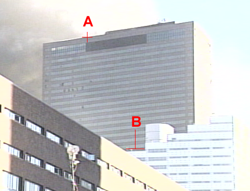
The reason I question the placement of point "B" is the displacement chart (fig.12-76) shows plotted points to ~240'. I count at least 29 floors (window breaks) under point "A". Unless the floors are really small, the fig. ends well before a point directly under point "A". If I'm way off, correct me (I don't mind).
(I'm manually counting windows)
Last edited:
Because the top of the windows on floor 29 can only be seen in that region (B). The trace extends the full 242ft NIST suggest for the distance above that point to the roofline...therefore the trace had to be lined up with region B.I know they said "until the view was obscured by the building in front"(paraphrased). How do we know that point is "B" and not a point directly under "A"?
(Only to floor ~33 can be seen below region A)
Last edited:
femr2:
The reason I question the placement of point "B" is the displacement chart (fig.12-76) shows plotted points to ~240'. I count at least 29 floors under point "A". Unless the floors are really small, the fig. ends well before a point directly under point "A". If I'm way off, correct me (I don't mind).
Floors are numbered from the bottom up
Count down from 47 to region B.
DGM
Skeptic not Atheist
Floors are numbered from the bottom up
Never mind. I found my mistake (damn building owners that expect me to work after they close).

Last edited:
Hmm.I know this (I work on these things)
I count at least 29 floors (window breaks) under point "A".
The alternating light/dark bands are in pairs.
One pair per floor.
The NIST displacement trace has to be from above region B
Last edited:
DGM
Skeptic not Atheist
See above.I was being more than gracious, but...
So NIST say the lowest point is the top of the windows on floor 29, and you have managed to count *least 29 floors (window breaks) under point "A".*. Cool
You have at least a 58 storey building by now.
Are you telling me that after all these years you don't know that the alternating light/dark bands are in pairs ?
One pair per floor.
Here's a big copy for you
http://femr2.ucoz.com/_ph/3/370825048.png


I'm working on a job where they actually expect the real licensed equipment operator to show up (me).
My (tired) bad.
alienentity
Illuminator
- Joined
- Feb 21, 2009
- Messages
- 4,325
I know they said "until the view was obscured by the building in front"(paraphrased). How do we know that point is "B" and not a point directly under "A"? I don't recall them clarifying this, is this a literal interpretation?
(I'm sorry if you covered this already, a link will do if so).
NCSTAR 1-9 Vol 2 p 601
'To obtain a better understanding of the vertical motion of the building in the first several seconds of descent, the motion of the north face was studied in more detail by tracking the vertical position of a point
near the center of the roofline using the same video. In the following discussion, the time at which motion of the roofline was first perceived (6.9 s) is taken as time zero. '
A different point only identified as 'near the center'. 'B' is 'near the center', it would be logical that they used a point directly above it.
However, Femr2 claims, strangely, that this is not possible.
That's where his argument fails, IMO. He doesn't know where it was, and he hasn't contacted NIST to find out, so he seems to be in limbo. (hard to disprove something if you don't know what it is)
No worries. Have edited my post. Feel free to update your quote of it.My (tired) bad.
alienentity
Illuminator
- Joined
- Feb 21, 2009
- Messages
- 4,325
Floors are numbered from the bottom up
Never mind. I found my mistake (damn building owners that expect me to work after they close).
Good. Count up 18 floors from the 'B' region, that's the vicinity where they tracked the roofline for descent, obviously.
DGM
Skeptic not Atheist
No need, I can take my (self imposed) licks.No worries. Have edited my post. Feel free to update your quote of it.
