BenBurch
Gatekeeper of The Left
Drifting a little off the beam here, back to data and ice extents, please.
Drifting a little off the beam here, back to data and ice extents, please.
Not at all. That "could" looks like it was a "can" in the original assertion -by that consecutia temporum thingy of Indo-European languages-. "Can", "2013", and "ice free summers" look much precise, focused and settled than "will probably", "this decade" and "summer sea ice gone", so the article is just trying to inform that forecasts for 6 years on are now more prudent and well informed.Anyone else see the problem with this statement?Scientists who predicted a few years ago that Arctic summers could be ice-free by 2013 now say summer sea ice will probably be gone in this decade.
Tracking with last year right now;
If focusing in short term adds something:
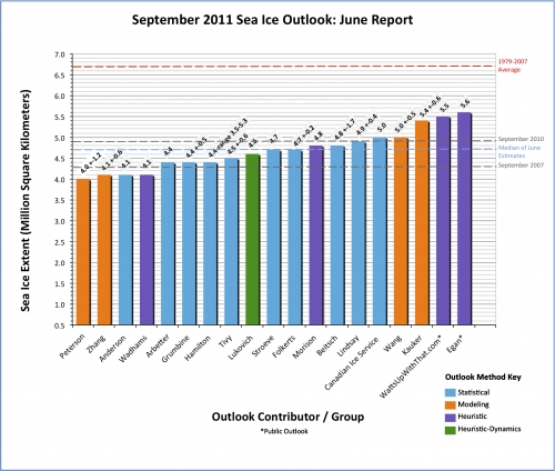
SEARCH: September Sea Ice Outlook: June Report
[qimg]http://www.arcus.org/files/resize/search/sea-ice-outlook/2011/06/images/pan-arctic/sio_panarctic_june_fig1-500x424.jpg[/qimg]
We are also entering a neutral phase in Niño/Niña. How did this use to affect sea ice extension?
")
 ... among the public .... .... with bracketed values to choose .... ... at ... ... Oooh!!! Eeeeh!!! Watts Up With That!? Watts Up With That!? ... Oooh!!! Eeeeh!!! Watts Up With That!? wattsupwiththat.com!? [http: // wattsupwiththat .com /2011/05/19/sea-ice-news-call-for-arctic-sea-ice-forecasts-plus-forecast-poll/] (sorry, I'm not boosting its pagerank in Google)
Interesting link. The rest, though equally interesting, I'm afraid it's pretty much off-topic. We have to deal here with Arctic sea ice as a system itself. We have to almost totally ignore external parameters that may set structural changes in motion and focus in the system structure itself. We may name consequences or associations, but we only can analyze them if they have an evident feedback on the Northern sea ice system itself. We may analyze deep changes in the system's structure and name consequences -that's why I quoted your reference to global uptake of atmospheric gases- but that's pretty much it.Take a look here NASA Study Shows Role of Melt in Arctic Sea Ice Loss. the problem with measuring ice loss is several. One is that we have very little knowledge of the underground streams of meltwater that lubricate from under the ice sheets, that's whats worrying with west Antarctica for example. There are guys tying to measure it sending down probes a couple of hundred meter etc but it's terribly tricky to get it to work. Satellites are our best friend as it is for the moment, and I hope NASA get the money to continue. The melt water will impact on the streams and salinity, creating a different climate for plankton and krill as the water heats up. The oceans acidity the global uptake of CO2 brings with it, is a added problem, and a very serious one in that it seems to stop the creation of shells, not only reefs but some plankton species too.
All the information is here: http://nsidc.org/arcticseaicenewsIs anybody covering the winter maximum extent? How much does it bounce back each year, is it changing, and are there trends? If so, do the winter max trends align with summer min trends?
March 2011 had the second-lowest ice extent for the month in the satellite record, after 2006. Including 2011, the March trend in sea ice extent is now at -2.7 percent per decade.
About the planetary ice anomaly, there's that graphic updated daily that I linked in last year's thread about this same topic.
Again, what's expected during Northern Summers and Springs under neutral Niña to Niño conditions? What about the Arctic Dipole Anomaly?
") .
.Interesting link. The rest, though equally interesting, I'm afraid it's pretty much off-topic. We have to deal here with Arctic sea ice as a system itself. We have to almost totally ignore external parameters that may set structural changes in motion and focus in the system structure itself. We may name consequences or associations, but we only can analyze them if they have an evident feedback on the Northern sea ice system itself. We may analyze deep changes in the system's structure and name consequences -that's why I quoted your reference to global uptake of atmospheric gases- but that's pretty much it.
But, as it's an ill wind that blows nobody any good ...
... focusing in Northern sea ice extent has its own merits and many opportunities for skeptical analysis, debunking and healthy criticism.
.) And make your guess. Depending on your models, and whom you 'trust', you will get different answers. But the satellites are our best answer, up there, as I see it, giving us the best predictions. "Two that are currently in space are GRACE, which measures gravity, and the Aqua/Terra satellites that have visible imagery for watching the glaciers. There are also infrared satellites the measure temperatures. ICESat1, monitoring the ice sheets by monitoring the surface elevation," was in space until 2009 with the next ice satellite replacing it not to be launched before 2016, (depending on budget cuts.). "The Ice, Cloud,and land Elevation Satellite-2 (ICESat-2) is the 2nd-generation of the laser altimeter ICESat mission (January 13, 2003 to August 14, 2010). ICESat-2 is scheduled for launch in early 2016." Icesat2. So it comes down to dedicated guys looking over thousands of old logs, and then trying to make them make sense. That's how we tracked water temperatures and streams historically for example. They do a he* of a unappreciated work those guys, and as the old 'data' has no predefined, agreed on before, structure it leaves a lot to define. But it do give us a trend. Until then we have a bad gape that we try to cover by using manned aircrafts, in no way giving us the same coverage. That's not good, we really need those data. Then we have 'history' of course, that means those 'statistics' that may be kept, the problem there being Capitan Ahab never really realizing that we would need his data
And if you're looking at 'ice loss' I think you need to cover Antarctica too ...