Look at the trajectory of the NOC plane you drew..
I guess I'll just need to keep repeating this until it sinks in: My drawing does not show any "trajectory." It's a scale drawing that shows Paik's approximate
vertical field of view out that window. In the interview video, Paik points out that window at about a 35
o angle to indicate where he saw the plane. From that video, I estimate that he could not possibly have seen upward at more than a 45
o angle. I have indicated those two
angles in my drawing. Are you with me so far?
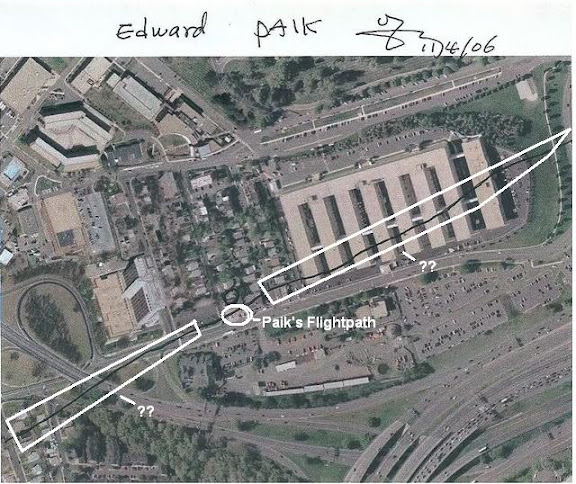
Now look at the MAP Paik drew.
I have. He drew a path that crosses over his parking lot, perhaps 30 feet SSE of that window.
Now look at topography of the area. In this instance the position of Paik´s shop in relation to the 200ft+ Sheraton Hotel..
Which is completely irrelevant to the point of my drawing. Please try to focus on Paik's vertical field of view out that window.
That this trajectory is possible to accomodate the 128ft wingspan..
Now it's my turn to call
your attention to Paik's map: He has the plane flying over the Annex building after passing over his parking lot. That building is about 70 feet tall. Are you still with me?
So your depiction of the NOC plane´s trajectory is well off. You are taking a literal translation of what he said and placing the plane where it could not physically be on an impossible trajectory.
But there
isn't any "depiction of the NOC plane's trajectory" or any other "trajectory" in my drawing. I have one depiction of the plane directly over Paik's head and at the bare minimum altitude if would need to clear the Annex building (even if it were in level flight at that point, which it wasn't), which simply shows that if the plane had really passed there, then Paik wouldn't have seen it. I have a couple of other arbitrary depictions that are not any attempt to indicate a particular flight path or trajectory, but rather a simple fact of geometry: For Paik to have seen the wing and fuselage out that window, the plane must have been
at least as far SSE of that window as it was above the ground. If the 35
o angle he is pointing to in that video is reasonably accurate, then it was even farther away than it's altitude. I've lost count of how many times I've said that now, and yet you still say this:
His map reinforces the inaccuracy of your interpretation of the trajectory and DISTANCE from his POV.
He clearly places the plane over his front yard where he described only the right wing as being visible.
And there's the point that you seem to be determined to not understand. If the plane was on the path he drew on the map, maybe 30 feet SSE of that window, and he was looking up at a 45
o angle or less, then the plane would have been at an altitude of 30 feet or less. If the plane had been anywhere near that low, there is no way it could have cleared the Annex building. QED, Paik's map
CANNOT be accurate, unless he lied about seeing the fuselage. Get it now? Either Paik's map is wrong, or he didn't see the plane. Which would you like to go with?
Your "SOC plane"...how relative is it to the actual proposed SOC path?
The left wing of your "SOC plane" closest to the "NOC plane" is actually overlapping the wing of the "NOC plane"
The furthest "SOC" plane
Just WHERE do YOU believe SOC actually was??
That's a stupid question. Draw a line from where the plane hit the Pentagon back through where it knocked down the the lightpoles, and you've got it. You seem to have forgotten that you're supposed to be proving that's not right. Paik's inaccurate map certainly doesn't do it, nor does what he said he saw out that window, not does Balsamo's graphic.
It is roughly 430ft. from Paik´s shop to the fuselage of the plane on the SOC path.
Ok, so if it was somewhere around 350 to 400 feet up, no more than 430 feet up, then that would be about the angle he pointed, wouldn't it. You've supposed to be proving that's not the case.
Going by scale, given the plane is 128ft from tip to tip and that the far "SOC plane" is two plane lengths away from Paik´s shop, you are placing the plane @260ft away.
No, I'm not "placing" the 260 ft away. My drawing simply concerns the angle at which Paik viewed the plane and what that implies. The entire problem is that neither you nor I nor Paik can use
that angle alone to "place" the plane. But what my drawing shows is that
Paik's placement on the map
can't be right. And if it's wrong, it's meaningless.
The scale of the Navy Annex to Paik´s shop?
The Navy Annex is 4 stories tall @69ft.
You have Paik´s shop scaled to 6mm.
You have the Navy Annex scaled to 7cm.
Are you really trying to say that the Navy Annex is almost TWELVE times taller than the shop??
Doesn't make a bit of difference, since the important feature is that Paik couldn't have seen more than about 45
o up. That and the rest of your post are irrelevant, since you still didn't seem to understand what I was getting at. I do hope this helped.
")