• Security incident: ISF was recently accessed by intruders. Please change your password, and change it anywhere else you used it. Read more

[Split]Debris piles at GZ- split from: UL Moves For Sanctions Against Morgan Reynold

Consider the picure below. I've added outlines of the WTC over the LIDAR data pic. I think the outlines are roughly accurate as to the positions of the footprints of each structure.
This gives a fairly good refutation of the fallacies that jammonius attempts to propagate here.

I ask again, why, if (as jammonius previously stated) WTC7 was also destroyed with DEW technology, does the data show the remains of the building to be considerably higher than his "flat 1 storey at GZ" assertions?
Why did this building not suffer the mythical "midair disintegration"
Answer please jam.


8748485ae85b375ef.jpg


BV
​
 
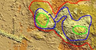
I think jammonius might be a little color blind w/ the shades of yellow, so let me assist. Maybe if I'm bored later I'll do the rest of the gz map.

[qimg]http://phunkadelic.org/duck.jpg[/qimg]

The area between the red and blue is in the 25-50 foot range.
The area between the blue and green is in the 50-75 foot range.
The area in the green is in the 75-100 foot range.
This does not fit any definition of the word flat.

Looks kinda like a duck heheh.


duck.jpg


First things first. Thank you for the helpful additions to the Lidar diagram. The added graphic touch lends clarity to the discussion.

Now, for additional clarity, let's also add in bonavida's equally important graphic enhancement:

8748485ae85b375ef.jpg


Now, let's see what information we can jointly discern:

I'll start with what I see:

1--The graphic in the quoted section only covers WTC 3 and WTC 2; that and nothing more. In fact, it doesn't appear to include all of the WTC 3 footprint. One can argue that the 2 lidar images do not fully agree one with the other, but that is not considered by me to be all that significant for purposes of this aspect of the discussion.

By "this aspect" I think what we're here actually doing is determining whether the word "flat" is adequately descriptive or not. As outlined in the remainder of this post, I contend these data justify use of the word "flat" as being adequate, generally accurate and certainly descriptive.

Words can mislead and summary type descriptions are not an adequate substitute for a full-blown, pixel, by pixel assessment. That is how language works. Some descriptions are intended to convey an overall sense or concept, others are designed to explain out to, say, the Nth degree.

It appears we are morphing more towards doing the latter. However, where I disagree with some posters is that if that is what we're doing, then that is not a proper way to discuss the term "flat." That term is intended to convey an overall summary of the conditions. Plus, any attempt to characterize it otherwise is nothing more than a cheap trick.

General is general and specific is specific.

Now, with regard to the graphic in the post with the circular or eclosing lines, let me give my impression of the specifics there shown.

1--There is an area that is worth mentioning that you did not include; namely, the area between the outer border of the chart and the red. Keep in mind, this is a small segment only covering WTC 3 and 2. All of it is, I believe, within the confines of GZ because we can see that the pedestrian walkway is at the outer edge.

I contend that the area from the border to the red boundary is "street level" or zero and therefore well within the general description of being F L A T.


2--In percentage terms, I assert the area from the border to the red is the single largest component of that graph, comprising, I would say almost 1/2 of it and easily more than a 1/3 of the total. It's almost like a sandwich sliced on an angle, where the two halves of the sandwich would be considered by 10 year kids as being a roughly equal split. And, in my experience, 10 year old kids look very, very closely and accurately at who's getting the bigger piece. So, if a sandwich isn't cut evenly they squawk. I assert kids wouldn't complain about those slices. So, in conclusion, 1/2 of the graph you posted is flat.

3--Between red and blue, not all of it is in the 25' category. You can see the light tan in portions. Granted, they are not large in percentage terms relative to the whole of that area, but they are visible and merit mention. They also help to provide a way of deducing that the 25-50' spread may be closer, overall to the 25' range.

4--No one has said what number of storeys are considered to be covered here. I would assume that 1 storey would equal at least 10' if not 12' such that 25' is 2 storeys.

5--Now, as to percentage of whole. The 25-50 category is also the second largest in percentage terms based on what I see. I would estimate that portion at about 1/3 of the total, and I wouldn't quibble if some were to argue for, say, 30%.

6--This means 80% of that graphic is 0-25, 50' tops.

7--Or, to use my word "flat" when one considers that what had stood there had been 1360.' This brings up another point. The word "flat has a context. The context is before and after destruction of the Twin Towers and other buildings in the WTC complex. Just the towers alone aggregated 2720'. But, since the graphic in question only covers one of the towers, I wouldn't quibble if some were to insist that the height of only one should be used for context purposes. Mind you, a fair claim can be made that since the two towers were so close one to the other, it's proper to use the 2720' as a reference. If one does so, then that means a 99% reduction. I think if something is compacted to 1% of its former height then, by comparison, what remains is freakin' FLAT. Even if you halve that, you still get a reduction down to 2% of its prior height and that is still FLAT.

8--The claim is 75' for the area between blue and green and it is, I would say, about 15%.

9--5% accounts for the peaks.

Nope, posters, that graphic reveals a flat GZ IMHO.

 
Last edited:
Of course, I completely agree that when you include the state of Kansas as an integral part of Manhattan, Ground Zero can be considered as being flat.

It is a pleasure to see that you admit that the debris piles must have been 8 storeys, and that only by including the surrounding roads and structures, many of which were not inside the perimeter of the WTC block (such as the skybridge), can one make a claim of lack of grade over the "site" as defined by one with an agenda. I am grateful for your help in identifying these types of misrepresentations generated by the charlatans within the Conspiracy Theory ranks. Without your clever insight on the types of arguments one would make if one was fully committed to a theory with no factual support, I would never have thought of this approach.

Many thanks!
 
I would assume that 1 storey would equal at least 10' if not 12' such that 25' is 2 storeys.

---

6--This means 80% of that graphic is 0-25, 50' tops.

---

Nope, posters, that graphic reveals a flat GZ IMHO.

Anyone see those goal posts?
 
Of course, I completely agree that when you include the state of Kansas as an integral part of Manhattan, Ground Zero can be considered as being flat...

Many thanks!

Maybe, if you replace Kansas, with Monument National Park! Or view it from the bottom, of the Grand Canyon. Maybe...:rolleyes:
 
Well, it appears the forensic approach has been abandoned.

So, there's no longer any serious discussion of the flatness of GZ. Cool.

duck.jpg


The above graphic is intriguing -- to me -- for a second reason; the issue is WTC 3.

Why should that building have disappeared? After all, no plane hit it. It didn't have the fireproofing from its steel beams dislodged; and, there's no significant cross over from WTC 2 to it. Afterall, the Lidar clear shows a clear drop off in debris from 25' to 0' as depicted by the way in which the red and blue areas are shown to be discreet piles. One pile for WTC 2 and one pile for WTC 3.

So, there was no kerosene, no jarring and not even an indicator, from the Lidar, that there was any impact from WTC 2 because all of WTC2's debris exhausted itself inside its own blue line area.

Needless to say, this information is considred to be consistent with destruction by a discreet attack on WTC 3.

I know, I know, Manhattan is in Kansas and ha,ha, he,he, let's all have fun.

But, just so you know, there are those who will take a close forensic look at the anamolies associated with the visual evidence in order to infer causation.

As things stand, the standard version of events in no way accounts for the annhilation of WTC 3.

Of course, the standard version is false. WTC 3 was flattened by DEW, folks.
 
No actually much of the area between wtc2 and wtc3 is burried by between 25-50 feet of debris.
 
and whatever is underground. remember dr wood ignores the underground pile.
 
Lookit, we present the high calorie evidence on a plate, but jammonius forlornly forks through the side salad and picks out the cherries. Perhaps every morning she looks in the mirror and thinks her brain is getting fat?
I think jammonius is an intellectual anorexic.

BV
 
The photos in posts 553, 555 & 558 fully substantiate that the debris at the WTC was from 30 to 100 high. Case closed.

Thanks Jammonius for starting this thread which gave forum members a place to post those photos.
 
Declarations are not analysis. In any event, an assessment of the posts in this thread will reveal that from page 1 to page 15, the height proposed for GZ has diminished a great deal from its starting point. It as also morphed from the low point that I had asserted, namely <1 storey to a point that is about 2 storeys. Post 572 immediately above hints at this in that 30ft is at the 2 storey level. The declaration of 100' as a high does not alter the 2 storey claim because there are obvious peaks here and there, with the highest of those being the WTC 7 pile.

Given the combined height of 2720' for just WTC 1,2, a debris stack of 30' represents approximately 1% of that total. I assert, therefore, that it is descriptively accurate to refer to GZ as flat.

Posters here abandoned all attempts to prove there was significant underground debris measured in inches, let alone storeys. That claim has clearly not been proven, so it is highly troublesome that posters here continue to rely on it.
 
The declaration of 100' as a high does not alter the 2 storey claim because there are obvious peaks here and there, with the highest of those being the WTC 7 pile

Again I ask, if, as you state, WTC7 was destroyed with DE weaponry why wasn't it also "disintegrated in mid-air"? Why did WTC7 (considerably less massive than either tower) leave the highest pile?
Please answer.

BV
 
Given the combined height of 2720' for just WTC 1,2, a debris stack of 30' represents approximately 1% of that total. I assert, therefore, that it is descriptively accurate to refer to GZ as flat.

Two separate piles, so your reference is inaccurate. (Crude approximation to follow) If you take each floor and assume that it is approximately 1 ft thick, stacking only the floors on top of each other would result in a 110 ft high pile. This of course discounts compression of the material and run off of the crushed debris. Accounting for the material that fell into the basements, as proven to you though you fail to see, this would reduce the pile by say another 40 ft. So, a debris pile in the range of 70 ft is what can be expected.

How tall should the debris pile be?
 
Why should that building have disappeared? After all, no plane hit it. It didn't have the fireproofing from its steel beams dislodged; and, there's no significant cross over from WTC 2 to it. Afterall, the Lidar clear shows a clear drop off in debris from 25' to 0' as depicted by the way in which the red and blue areas are shown to be discreet piles. One pile for WTC 2 and one pile for WTC 3.

So, there was no kerosene, no jarring and not even an indicator, from the Lidar, that there was any impact from WTC 2 because all of WTC2's debris exhausted itself inside its own blue line area.

Needless to say, this information is considred to be consistent with destruction by a discreet attack on WTC 3.

Yeah gosh, what could have caused the destruction of WTC3?

pic3.jpg


Oh, thousands of tons of steel falling hundreds of feet impacted the building. Mystery solved!
 
I think jammonius might be a little color blind w/ the shades of yellow, so let me assist. Maybe if I'm bored later I'll do the rest of the gz map.

http://phunkadelic.org/duck.jpg

The area between the red and blue is in the 25-50 foot range.
The area between the blue and green is in the 50-75 foot range.
The area in the green is in the 75-100 foot range.
This does not fit any definition of the word flat.

Looks kinda like a duck heheh.

I see the duck eating a bun, however as someone who is more than a little colourblind, I can see the blue and that is it. (Using Red and Green Pfffft *grumble* I negatived the picture and used a colour filter)

Thankyou for contouring it though because it just looked like a close up of salt corroded plate and could see bugger all
 
My bad, I'm not color blind myself so I didn't know what colors were best to use. I just went for something other than the shades of yellow they used in the lidar map.
 
I see the duck eating a bun, however as someone who is more than a little colourblind, I can see the blue and that is it. (Using Red and Green Pfffft *grumble* I negatived the picture and used a colour filter)

Thankyou for contouring it though because it just looked like a close up of salt corroded plate and could see bugger all

Oh! There was green! :-)

Slightly color blind here too...
 

ISF - Join now!

Every member here is approved by hand. No bots, no spam, just people who care about evidence and honest debate.

Membership is free!

Create your free account

Back
Top Bottom