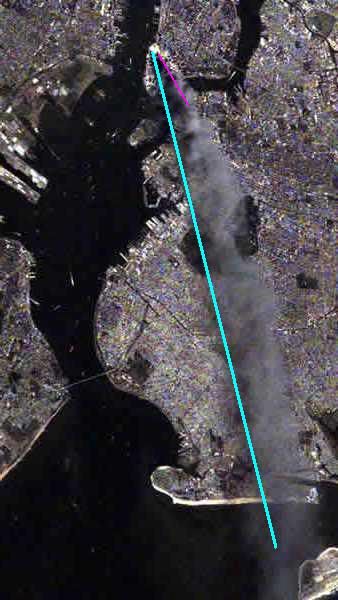
I said the wind was NNW or 355° or "from NNW to SSE".You said the smoke was blowing NNW, are you sure about that??
You are using an out of date browser. It may not display this or other websites correctly.
You should upgrade or use an alternative browser.
You should upgrade or use an alternative browser.
Answer the point, achimspok. Draw some pointers to the intact windows if you wish.
Meanwhile, in your graphic just above, why do we see no smoke travelling west across the face of the building prior to being swept away from the SW edge?

Maybe this will help you to see more than one movement in the smoke.
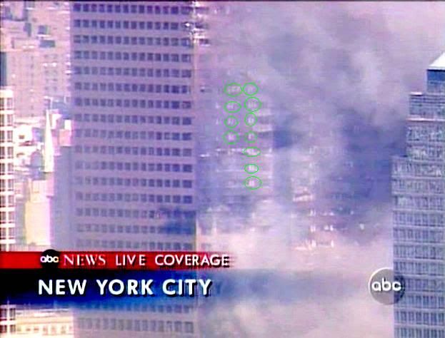
Most of the light appearing "windows" are the spaces between the windows (vertically and horizontally) where the brown cover fell off. Some of the windows appear white or half white to. For me it looks like blinds pulled down half the way or falling down due to the impact of the debris.
Yes you are absolutely correct. Assuming the film was broadcast live (as opposed to shown during a live transmission) then the azimuth is ~205. This means it is shining almost directly onto the face of WTC7 (+/- 5°). So what are the highlighted light patches here given that they are on the 'window line' rather than the 'facade line'? Vertically synchronised lines of blinds?
Yes. You continue to misrepresent the prevailing wind. Certainly it changed during the day, but you keep on claiming 355 (even though 355 is a serious overestimate) based on the blue line you originally drew on the plume in the satellite photo. 'Because you could' is about the only justification I can see for that heading.
Clearly the red line below is a better estimate of the wind in S Manhattan, at that time.
alienentity
Illuminator
- Joined
- Feb 21, 2009
- Messages
- 4,325
Right, but NIST obviously mapped larger areas while there were a lot of unbroken windows especially along the SW edge
Meaningless. The chart shows where windows were broken. It doesn't speculate about the blue areas.
Your muddled thinking doesn't seem to comprehend that, on the NIST chart, windows along the SW corner were broken from floor 7 right to the top.
Not surprisingly, smoke was pouring from many of those windows in several photographs.
Hmmm....that's why you're in denial.

The longer this conversation goes on, the more it reminds one of the 'no plane debris was recovered at Shanksville' stuff of no-planer Jammonius. It's actually rather sad that you need to do this.
A little late but you finally got it. At least it seems so. Given the fact that floors 11-13 are either yellow, orange or red we should see any sign of a huge fire in the south east of these floors at 1pm, no?
Translate into English please. Currently indecipherable. ETA don't bother, I don't think it will help you to restate your ideas again. It's just too tedious to persist.
Last edited:
alienentity
Illuminator
- Joined
- Feb 21, 2009
- Messages
- 4,325
Yes. You continue to misrepresent the prevailing wind. Certainly it changed during the day, but you keep on claiming 355 (even though 355 is a serious overestimate) based on the blue line you originally drew on the plume in the satellite photo. 'Because you could' is about the only justification I can see for that heading.
Clearly the red line below is a better estimate of the wind in S Manhattan, at that time.
[qimg]http://i250.photobucket.com/albums/gg274/sap-guy/911plumedirections.jpg[/qimg]
Yes indeed. And unfortunate for achimspok's wind vortex theory as well. But his is a desperate strawman argument anyway, judged from various criteria.
This is just another piece of info which invalidates his claims.
ETA I've had enough of achimspok's nonsense for the time being. Done with this thread, the claims have been well refuted even if he is incapable of accepting it.
Last edited:
Yes you are absolutely correct. Assuming the film was broadcast live (as opposed to shown during a live transmission) then the azimuth is ~205. This means it is shining almost directly onto the face of WTC7 (+/- 5°). So what are the highlighted light patches here given that they are on the 'window line' rather than the 'facade line'? Vertically synchronised lines of blinds?
[qimg]http://i250.photobucket.com/albums/gg274/sap-guy/wtc7groove2b.jpg[/qimg]
sun azimuth 225° almost directly from behind the helicopter:

Do yo see the bright column in the sun? These columns went up to the roof.

ETA I've had enough of achimspok's nonsense for the time being. Done with this thread, the claims have been well refuted even if he is incapable of accepting it.
I agree! In fact, the same goes for the rest of the 9/11 Truth gang that lurks here on JREF!
Yes. You continue to misrepresent the prevailing wind. Certainly it changed during the day, but you keep on claiming 355 (even though 355 is a serious overestimate) based on the blue line you originally drew on the plume in the satellite photo. 'Because you could' is about the only justification I can see for that heading.
Clearly the red line below is a better estimate of the wind in S Manhattan, at that time.
Uh, Glenn... I already explained it, didn't I? But may be you want to find me any image of the smoke over the brookly bridge. The "better estimate" is the bigger nonsense. Do you believe in smoke bananas?
I try to explain it again.
1) you have to turn the image 90°CCW because the satellite was somwhere in the west

2) you have to consider the elevation of the smoke

3) look at the images shot that day and you can figure out the direction of the smoke (no banana all day long)

You posted 300 degrees in one of your posts, and you are off over 50 degrees now. You debunked yourself. Review your posts. Fire was in WTC 7, it was fully involved, looked like a massive fire to those passing by, who lived through attacks by terrorists you apologize weakly for. How do the winds work on your attack on NIST?I said the wind was NNW or 355° or "from NNW to SSE".
You should study the science of weather before making the mistake of showing wind direction from space and drawing a failed direction. Are you trying to back in demolition, the big inside job conspiracy?
Using winds as an excuse to down play the massive fires in WTC 7, the fires which destroyed WTC 7, is not valid.
Last edited:
Yes, if you like to interprete the chart not as areas but saying it is precise for each window then the chart is wrong.Meaningless. The chart shows where windows were broken.
Yes, I posted a damage mapping 4 month before NIST and my "blue areas" were smaller.It doesn't speculate about the blue areas.

If the holy report says so + you tell us that yellow means "every single window in that area is damaged" + you tell us that "no granite and truss damage can be found" in the yellow area because otherwise it would be orange...Your muddled thinking doesn't seem to comprehend that, on the NIST chart, windows along the SW corner were broken from floor 7 right to the top.
You are a liar Alienentity and your "expertise" is as good as holograms and space beams.
Not surprisingly you don't understand simple physics and deny the obvious.Not surprisingly, smoke was pouring from many of those windows in several photographs.

I'm not.Hmmm....that's why you're in denial.
poor boyThe longer this conversation goes on, the more it reminds one of the 'no plane debris was recovered at Shanksville' stuff of no-planer Jammonius. It's actually rather sad that you need to do this.
hasty retreat: "I do not understand".Translate into English please. Currently indecipherable. ETA don't bother, I don't think it will help you to restate your ideas again. It's just too tedious to persist.
I know you don't.
Translation:
NO SMOKE OR FIRE FROM OPENED WINDOWS AT 11, 12, 13 AT 1PM
while at the same time the smokey fire smoked through undamaged windows in the 30th floors where no fire was observed throughout the day.
I guess the fire took a little lunch break after heating up the SE quater of 11, 12, 13 to 500-1000°C.
No beachnut, I did not. I argue all the time that the wind was almost precisely north the entire day (if you analiyze the images and videos). Central Park measured 300°. I wrote several posts earlier what I think about wind directions measured at ground level near Central Park.You posted 300 degrees in one of your posts, and you are off over 50 degrees now. You debunked yourself.
Are you talking about 11am or 1pm or 3pm or 5pm? You first have to understand what you see. The 3 collapses sounded like explosions to those passing by, who lived through attacks by terrorists you never properly identified.Review your posts. Fire was in WTC 7, it was fully involved, looked like a massive fire to those passing by, who lived through attacks by terrorists you apologize weakly for.
You should learn the basics of perspective before you tell me what I should study. Your smoke banana obviously suggests the eye of the tornado somewhere near Newark Airport.How do the winds work on your attack on NIST?
You should study the science of weather before making the mistake of showing wind direction from space and drawing a failed direction. Are you trying to back in demolition, the big inside job conspiracy?
Using winds as an excuse to down play the massive fires in WTC 7, the fires which destroyed WTC 7, is not valid.
Common Beachnut don't be shy. Give a little link to my mistake! Show me what you don't understand!"...before making the mistake of showing wind direction from space and drawing a failed direction."
Yes, you have shown a 100 times (sorry, a 101 times) that you have no clue about the things you try to debate. This is the nonsense you are defending right now.Yes indeed. And unfortunate for achimspok's wind vortex theory as well. But his is a desperate strawman argument anyway, judged from various criteria.
This is just another piece of info which invalidates his claims.
ETA I've had enough of achimspok's nonsense for the time being. Done with this thread, the claims have been well refuted even if he is incapable of accepting it.


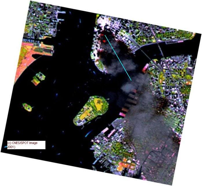
I asked you to present ONE image that shows the smoke above the Brooklyn Bridge. JUST ONE! Can't be that hard, can it?
Otherwise it would be the right time to admit that you FAILED again.
Last edited:
TSR
Illuminator
- Joined
- Mar 8, 2009
- Messages
- 4,783
[/quote]They had gerbils inside them?
Wow, the rabbit hole is deeper than I thought.
.
Ninja hamsters *disguised" as gerbils.
Seriously, does *no one* read my memos? Sometimes I wonder why I even try. No, get away from me, I do *not* want a hug from you...
.
TSR
Illuminator
- Joined
- Mar 8, 2009
- Messages
- 4,783
Nah, I went to Shiz, and if you messed with us we'd go all "eleka nahmen nahmen ah tum ah tum eleka nahmen eleka nahmen nahmen ah tum ah tum eleka nahmen" on your *ss.IggyRI? ...some metaphor in the sounding? ...talking in the third person.
Same school. A little anxious may be.
From the SPOT satellite at 822km height, 11:55 a.m.
[qimg]http://i250.photobucket.com/albums/gg274/sap-guy/911smokeplume2.jpg[/qimg]
Amazing! No smoke over the Brookly Bridge? No 300°? Well in the range of north +/- 45°. Fine. Where is the SPOT satellite? Maybe SW of NYC?

Looks like the SPOT is always 1/14 circumference of the earth ahead of the sun and therefore at 11:55 somewhere west of NYC.

Hence, we got the same result we already got before. Something like this:The orbit is also phased so that the satellite passes over the same point every 26 days. The satellite thus repeats the same ground tracks and the maximum distance between adjacent tracks at the Equator is 108 kilometres.
The combined field of view of the two instruments in twin-vertical configuration is 117 kilometres, so the entire Earth can be covered in a single 26-day cycle.
Lastly, the orbit is Sun-synchronous so that solar illumination conditions vary as little as possible. The orbital plane forms a constant angle relative to the Sun direction and the satellite passes over any given point at the same local time within two minutes. The Equator crossing time is 10:30 a.m.
Source: http://spot5.cnes.fr/gb/systeme/310.htm

or this (about high noon):

And it doesn't change anything about this:


And still there is no reason to believe in any invisible inferno. There was none.

Dave Rogers
Bandaged ice that stampedes inexpensively through
no-smoker = no-planer
I prefer "non-smoker" as shorthand for this latest brand of denial. Can we use that instead?
Dave
sun azimuth 225° almost directly from behind the helicopter:
You forgot to deduct an hour for daylight saving.
You forgot to deduct an hour for daylight saving.
You are right. The better we should see the bright columns.