You are using an out of date browser. It may not display this or other websites correctly.
You should upgrade or use an alternative browser.
You should upgrade or use an alternative browser.
Proof of Photomanipulation
- Thread starter Mobertermy
- Start date
-
- Tags
- cit lloyde england pentagon
")
Oystein
Penultimate Amazing
- Joined
- Dec 9, 2009
- Messages
- 18,903
Well first of all, do you agree with my contention that the cab driver himself thinks the photos are manipulated?
Lloyd hasn't done one secomd of photo analysis. In particular, he never got out a map and never draw a line of sight.
I don't disagree with anyones lines of sight (in so far as "correct" lines of sight can be done for manipulated photos. I don't see how it changes my claim that the bridge and columbia pike are self-evidently on the wrong side of the cab.)
Fallacy: Assuming the consequence.
That CIT accused an innocent man of being an accomplice.
You are breaking into open doors here with this. It is not the issue.
Oystein
Penultimate Amazing
- Joined
- Dec 9, 2009
- Messages
- 18,903
Where else was Ingersoll when he took the photos (DSC_0412 and a few before and after)? Got any idea? Could you indicate that on a map?
(Also, the bridge is exactly there in the photo where it should be from the point of view I indicated ETA: close to the left margin of the photo).
(ETA: I asked 5 questions - you answered 1. Please revisit my older post and try to address all 5 questions. In addition, I asked why you ignored my post several times. Because of pride? I want a serious answer. I also want to know why you ignored 4 of 5 questions!)
In addition to these 6 unanswered questions I have a seventh, more fundamental:
Mobertermy, do you agree that re-construction of sight lines and viewpoints is a valid, useful and necessary method for the purpose of the kind of photo analysis we do in this thread?
Bumped for Mobertermy.
Where do you think Ingersoll was when he took DSC_0412 and the photos immediately before and after that?
Why do you think the bridge is on the wrong side of the cab in DSC_0412? I ee it on the correct side, so does Drewid, and probably everybody else who ever looked at it. You are the lone exception. You should give us a little photo analysis (ya know - point of view, line of sight) to explain why you, and you alone, think the bridge is on the wrong side of the cab.
Why do you dodge these questions so stubbornly?
Why do you think drawing a line of sight is not the way to go? How else do you determine on which side of what things should appear in a photo?
I Ratant
Penultimate Amazing
- Joined
- Apr 8, 2008
- Messages
- 19,258
.or the bridge for that matter
I think there's some videos of bridges being manipulated by flood waters in Oz.
I recall while in Germany seeing a Roman bridge that resisted manipulation for 2000 years or so.
Didn't connect to anything more, time and custom had passed it by, but there it was.
Dave Rogers
Bandaged ice that stampedes inexpensively through
What that does not explain is how the east part of the bridge is on the wrong side of the cab (and this has nothing to do with parallax).
Wrong. It has everything to do with parallax. In fact, it's a near-perfect example of parallax.
Dave
Oystein
Penultimate Amazing
- Joined
- Dec 9, 2009
- Messages
- 18,903
All,
I just noticed that Mobertermy has done an edit to the text on slide 17 of his slideshow. He's still wrong, though.
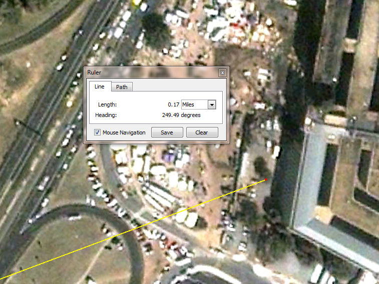
It would be easy to draw a line of sight: Just start at lamp D and draw between C and B. It runs nearly parallel to the flight path, at an angle of about 42° to the road. It becomes immediately clear that the traffic arm in photo #2 is TA3, and that the cab is just south of the bridge, and also slightly south of TA3 (assuming we place it on the lane divider between lanes 1 and 2). In other words: Exactly where Drewid, Dave Rogers, myself and everybody else who has analysed these photos in this thread, would place the cab. Only exception is Mobertermy, who obviously lacks the necessary skills.
sheeplesnshills
Illuminator
- Joined
- Mar 5, 2010
- Messages
- 3,706
It would be easy to draw a line of sight: Just start at lamp D and draw between C and B. It runs nearly parallel to the flight path, at an angle of about 42° to the road. It becomes immediately clear that the traffic arm in photo #2 is TA3, and that the cab is just south of the bridge, and also slightly south of TA3 (assuming we place it on the lane divider between lanes 1 and 2). In other words: Exactly where Drewid, Dave Rogers, myself and everybody else who has analysed these photos in this thread, would place the cab. Only exception is Mobertermy, who obviously lacks the necessary skills.
I agree, anyone who can't work out a line of sight is not really someone who should be analyzing photographs. Its not as if it takes complex tools.....google earth, cut and paste and MS Paint will suffice for most purposes.
I agree, anyone who can't work out a line of sight is not really someone who should be analyzing photographs. Its not as if it takes complex tools.....google earth, cut and paste and MS Paint will suffice for most purposes.
And enough spatial awareness to do some 2d rotation on a map view. That's what is missing here.
Mobertermy
Muse
- Joined
- Nov 10, 2009
- Messages
- 548
All,
I just noticed that Mobertermy has done an edit to the text on slide 17 of his slideshow. He's still wrong, though.
No, I didn't. Where do you think the edit is?
WilliamSeger
Philosopher
- Joined
- Nov 28, 2006
- Messages
- 5,092
Mobertermy, I'd really like to help you work this out for yourself. Oystein has suggested one sight line you can try, and here's another. Note in this slightly enhanced photo, past pole 112 there is a tree near the Pentagon:
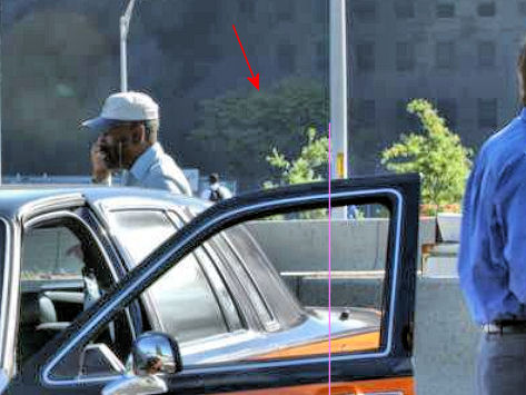
Note that a line from the right side of that tree that passes pole 112 also crosses the trunk of the cab. That tree seems to be gone now, but going back to historical Google Earth photos, we can find that tree:
(Since we can see at least 5 windows to the right of the tree, we can be sure it's not one of the trees farther south.)
Please try this yourself: Using Google Earth's ruler tool, or capturing the photo into a graphics program, you can draw a line from the tree through pole 112. If this line crosses the trunk of the cab, and we know from other photos that the cab straddles the right two lanes, then please answer these questions:
1. Where is the cab?
2. Where is the bridge?
3. What anomalies are you claiming in this photo?
If you're not going to attempt this simple experiment and answer these questions, then please just go away and let this silly thread die.
Mobertermy
Muse
- Joined
- Nov 10, 2009
- Messages
- 548
Photo #2 depicts columbia pike as running beneath rte 27 at angle much less than 90 degrees, such that the eastern portion of the bridge is to the south of the cab. Thats what the photo depicts. You claim this can be explained by foreshortening and parallax but haven not demonstrated this.
Mobertermy
Muse
- Joined
- Nov 10, 2009
- Messages
- 548
Will,
So where would the east part of the bridge be in relation to the cab accordingt to photo #2?
So where would the east part of the bridge be in relation to the cab accordingt to photo #2?
Dave Rogers
Bandaged ice that stampedes inexpensively through
Photo #2 depicts columbia pike as running beneath rte 27 at angle much less than 90 degrees, such that the eastern portion of the bridge is to the south of the cab. Thats what the photo depicts. You claim this can be explained by foreshortening and parallax but haven not demonstrated this.
Foreshortening. See post #432.
Dave
Dave Rogers
Bandaged ice that stampedes inexpensively through
Will,
So where would the east part of the bridge be in relation to the cab accordingt to photo #2?
Draw the sight line.
Dave
Mobertermy
Muse
- Joined
- Nov 10, 2009
- Messages
- 548
Foreshortening. See post #432.
Dave
Foreshortening won't change the location of the bridge.
DGM
Skeptic not Atheist
Well, it would appear that way to someone that's not willing to do any analysis.Foreshortening won't change the location of the bridge.

Mobertermy
Muse
- Joined
- Nov 10, 2009
- Messages
- 548
Another problem with the line of sight you have done for photo #2 is that poles B and C would be nearly lined up in them.
BCR
Master Poster
- Joined
- Dec 6, 2008
- Messages
- 2,278
Photo #2 depicts columbia pike as running beneath rte 27 at angle much less than 90 degrees, such that the eastern portion of the bridge is to the south of the cab. Thats what the photo depicts. You claim this can be explained by foreshortening and parallax but haven not demonstrated this.
Mobertermy,
I think people have been very patient in explaining why "Photo #2 depicts columbia pike as running beneath rte 27 at angle much less than 90 degrees". First, I have been through the underpass and it is not aligned 90 degrees with Rte 27. It does angle to the south slightly. If you draw a line-of-sight on GE from the location the photograph was taken and the bridge is exactly where it should be.
I'll upload some video of the roadways I took a few years ago which should give you a better feel for the area.