• Quick note - the problem with Youtube videos not embedding on the forum appears to have been fixed, thanks to ZiprHead. If you do still see problems let me know.

Flight AA77 on 9/11

one more question. if warren was a member of PFT, why did he not just use their copy of the data? why go through the whole motion of filing a FOIA request?

That is something you should ask him. All I can say is, when I began, I was a member of P4T but I wanted original data from the source myself so the NTSB was my first FOIA.
 
The 9/11 "truth" cult fanatics will be all over it soon enough, declaring the paper a fraud just like they did the NIST report on WTC7. Just give them time...

Yeah you just have to give them time to release one hand from their circle jerk long enough to type some emotional wailing.
 
I would like to see a detailed plot of the aircraft heading, to help the north or south of the Citgo station dialog.
 
I would like to see a detailed plot of the aircraft heading, to help the north or south of the Citgo station dialog.

I wonder if a sufficiently good plot of ground track could be derived from the VOR/DME data.

If I have read the NTSB report "Study of Autopilot, Navigation Equipment, and Fuel Consumption Activity Based on United Airlines Flight 93 and American Airlines Flight 77 Digital Flight Data Recorder Information" correctly, the right VOR receiver on AA77 was tuned to the station DCA at Reagan airport shortly after the hijacking and remained tuned thus, receiving signal for most of AA77's subsequent flight. The left VOR receiver was tuned to a nearby station in Virginia and then tuned to DCA at 9:32, about 5 minutes before impact.

If valid data from these receivers was recorded by the FDR, what should emerge is a series of points at which the distance and bearing to the ground station is specified. Since the location of DCA is known, perhaps this would permit the plane's ground track to be reconstructed solely from the FDR decode.
 
I would like to see a detailed plot of the aircraft heading, to help the north or south of the Citgo station dialog.
There is no north of the Citgo station, it was made up by idiots.

1TrueTrack77.jpg

Take google earth and put in 61.5 degrees for the last 3200 feet and you see a NoC is a idiotic lie, made up by morons. RADAR data verifies the official flight path and FDR course.
 
There is no north of the Citgo station, it was made up by idiots.

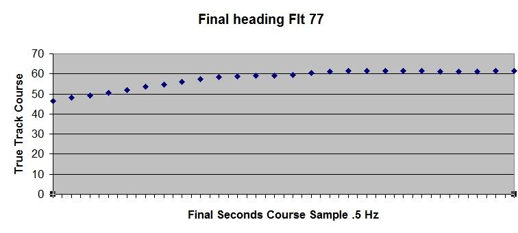
[qimg]http://i286.photobucket.com/albums/ll116/tjkb/1TrueTrack77.jpg[/qimg]
Take google earth and put in 61.5 degrees for the last 3200 feet and you see a NoC is a idiotic lie, made up by morons. RADAR data verifies the official flight path and FDR course.
.
I did that yesterday in the other thread... but I hadn't seen a heading plot in the latest publication which supported an extended straight flight for any length of time.
A less high-brow presentation of the time slice units is required on this heading plot here. Seconds, not '5 Hz, please.
Graphics should be used to educate, not intimidate.
 

Attachments

  • Pentagon-09132001-A.jpg
    Pentagon-09132001-A.jpg
    149.9 KB · Views: 22
.
I did that yesterday in the other thread... but I hadn't seen a heading plot in the latest publication which supported an extended straight flight for any length of time.
A less high-brow presentation of the time slice units is required on this heading plot here. Seconds, not '5 Hz, please.
Graphics should be used to educate, not intimidate.
.5 Hz is like seconds, cycles per second.
The descriptor for the data includes the sample rate.
Sampling Freq.(Hz): 0.5
Sorry, but it is a simple fact. Means there are only 2 samples with data for your ploto, your graphic. 61.5 degrees, and

The plot you have is an excellent approximation for the real path. Case closed. Perfect plot, remember Flight 77 is traveling over 800 feet per second at impact.

http://www.internationalskeptics.com/forums/attachment.php?attachmentid=20709&d=1295200358

Your plot on the graphic is good, and covers 4 seconds therefore the true track in the FDR is 61.5 degrees. In reality the plane is never going straight, your plot is perfect and is very close to the ground track 77 flew.
 
.5 Hz is like seconds, cycles per second.
The descriptor for the data includes the sample rate.

Sorry, but it is a simple fact. Means there are only 2 samples with data for your ploto, your graphic. 61.5 degrees, and

The plot you have is an excellent approximation for the real path. Case closed. Perfect plot, remember Flight 77 is traveling over 800 feet per second at impact.

http://www.internationalskeptics.com/forums/attachment.php?attachmentid=20709&d=1295200358

Your plot on the graphic is good, and covers 4 seconds therefore the true track in the FDR is 61.5 degrees. In reality the plane is never going straight, your plot is perfect and is very close to the ground track 77 flew.
.
Why is the speed, or better yet, the distance from impact not noted?
Seconds or hertz mean zip unless there's a modifier that converts time to speed/distance.
Quite important when relating the north or south problem, in that the plane -could- have come in north of the Citgo and turned, but not in the space available, nor survive the stress in such a turn, which would be worth noting for the NoCsayers to accept.

Because the plane does not know its about to hit something? 0.5Hz means IIRC that data is recorded once every 2 seconds. Not enough time for it to do very much without being recorded.
 
.
Why is the speed, or better yet, the distance from impact not noted?
Seconds or hertz mean zip unless there's a modifier that converts time to speed/distance.
Quite important when relating the north or south problem, in that the plane -could- have come in north of the Citgo and turned, but not in the space available, nor survive the stress in such a turn, which would be worth noting for the NoCsayers to accept.
over 800 feet per second. Hz means a lot. With speed and the fact the last two recored samples of 61.5, at .5 hz, solves all you need. It is neat to see CIT has no clue what Hz means.

here is the true airspeed. KTAS
470 ~5 seconds to impact
472 ~4 seconds to impact
476 ~3 seconds to impact
484 ~2 seconds to impact
488 last FDR value before impact

KTAS - True Course
470 - no sample
472 - 61.5
476 - no sample
484 - 61.5
488 - no sample

It gets worse, or better, with other data in the FDR we could calculate true course, independent of the true course stored in the FDR.
 
I just downloaded and corrected this image of the two flight paths to put North where it is always shown on such information.
I doubt the plane could have accomplished the heading alterations in the time available as shown on the red line, nor is there anything in the FDR data that supports the required control inputs.
Now, put the time hacks on the flight paths.
 

Attachments

  • Pentagonandcitgoannotated-A.jpg
    Pentagonandcitgoannotated-A.jpg
    74.4 KB · Views: 11
I just downloaded and corrected this image of the two flight paths to put North where it is always shown on such information.
I doubt the plane could have accomplished the heading alterations in the time available as shown on the red line, nor is there anything in the FDR data that supports the required control inputs.
Now, put the time hacks on the flight paths.

1flightpathstuff.jpg


Both those flight paths are impossible. The image purpose was good and valid but the flight paths are not possible, or close to reality. The image was only good for its purpose.
 
Last edited:
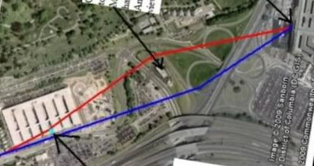
[qimg]http://i286.photobucket.com/albums/ll116/tjkb/1flightpathstuff.jpg[/qimg]


Both those flight paths are impossible. The image purpose was good and valid but the flight paths are not possible, or close to reality. The image was only good for its purpose.


Namely?
 
Last edited:
The aircraft speed.
It is not possible to change the headings as shown in the time available.
 

Attachments

  • Pentagon-09132001-B.jpg
    Pentagon-09132001-B.jpg
    149.6 KB · Views: 3
In the last two seconds, at the speed the airplane was going, that heading change would require a loading on the airplane of 4.6 G.
It -CAN'T- do that!
Physically impossible for an airplane like that to turn, much less survive that G loading.
 

Attachments

  • Pentagonandcitgoannotated-C.jpg
    Pentagonandcitgoannotated-C.jpg
    77.4 KB · Views: 4
Ever heard of aerodynamics? If you have you wouldn't ask such a stupid question.
.
The uninformed don't ask stupid questions.
Knowledge of aerodynamic principles is not common knowledge.
The poorly informed need to have misconceptions explained without rancor.
 
The aircraft speed.
Ever heard of aerodynamics? If you have you wouldn't ask such a stupid question.


I was asking him to name the valid purpose this facepalm image was good for. Is it from the "paper"?

Both those flight paths are impossible. The image purpose was good and valid but the flight paths are not possible, or close to reality. The image was only good for its purpose.
To show CIT are morons.
 
Last edited:

Back
Top Bottom